

Warm, Windy Weather, Rain Returns Late Tuesday Night
A strong upper-level system currently along the western U.S. coastal region will near the central and southern plains early this week bringing rain and thunder back to the state late Tuesday night, Wednesday, and possibly into part of Thursday before moving away from the region Friday into the weekend. The latest trajectory of the closed low will bring strong to severe thunderstorm threats across part of the area, with additional threats transitioning to heavy rainfall Wednesday into part of ThuMonday, April 26th 2021, 5:12 am
TULSA, Oklahoma -
A strong upper-level system currently along the western U.S. coastal region will near the central and southern plains early this week bringing rain and thunder back to the state late Tuesday night, Wednesday, and possibly into part of Thursday before moving away from the region Friday into the weekend. The latest trajectory of the closed low will bring strong to severe thunderstorm threats across part of the area, with additional threats transitioning to heavy rainfall Wednesday into part of Thursday. As of this point in the forecast process, our approaching weekend looks good.

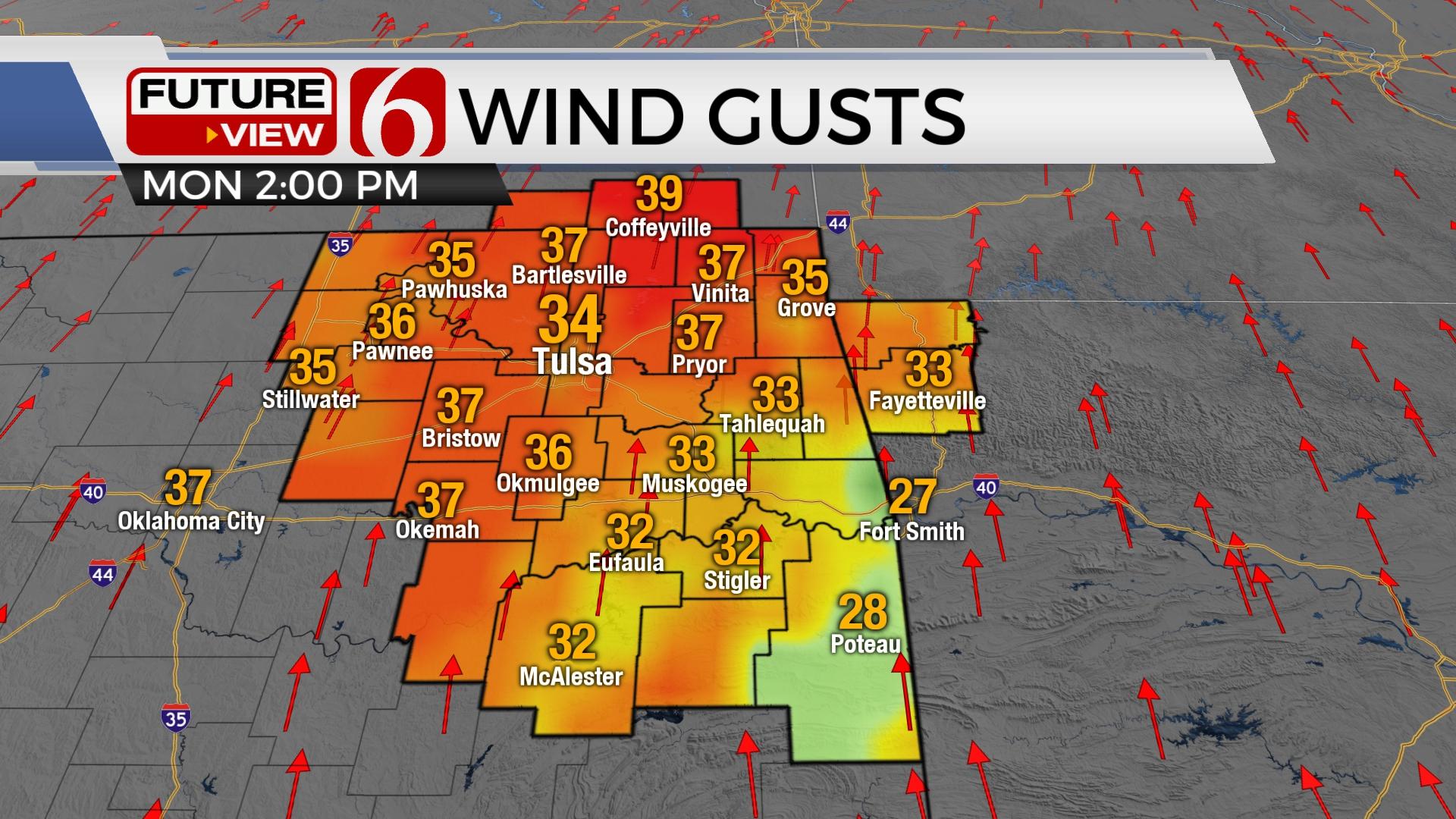
Today strong south winds from 20 to 34 mph will be likely, along with some slightly higher gusts near and west of the I-44 corridor. A wind advisory will be required for these portions of the region westward due to the deepening pressure gradient and continued strengthening of the strong southerly flow. Highs this afternoon will reach the mid-80s along with more sunshine and numerous high clouds. These strong south winds will quickly enhance low-level moisture with dew points reaching the lower 60s likely Tuesday into Wednesday. Higher and deeper moisture content is likely to arrive across north TX and most of southern OK with dew points reaching the upper 60s, possibly nearing 70. The amount of moisture available for potential rainfall will be quite high. Regardless of any severe weather threats, heavy rainfall and some flash or river flooding will be possible with this event.

The positioning of the incoming upper-level low is typical for mid-Spring. This feature will be approaching from the desert southwest and will initially move eastward nearing the state Tuesday night into Wednesday near Wichita Falls TX Thursday. But instead of ejecting northeast as a strong closed low, this system is projected to move southeast while slowly opening and weakening.
Tuesday, a surface low is expected across the central plains with a sharpening dry line extending southward into part of northwestern or western OK. As the first of several disturbances move around the basal portion of the trough, storms will fire Tuesday evening in the vicinity of this feature with all modes of severe weather possibilities across western and central OK. Storms will initially move northeast with some of these reaching the northeastern OK region. At the surface, a cold front will initially enter northern OK sometime Tuesday night late or Wednesday morning and slowly move southeast by Thursday morning to midday. This boundary will be the focus for several rounds of showers and storms during this period. Since the main upper-level system will be slowly dropping southeast, severe weather threats, while still present, may be higher across the southeastern part of OK into the Red River Valley, including all modes of severe Wednesday evening into early Thursday. More northward, along and behind the front, heavy rainfall will be the main hazard. Data output within the various models suggest between 2 to 5 inches of rainfall will be possible. This system finally moves far enough southeast by Thursday afternoon or evening and precipitation chances will end.

Temperatures during this period from Tuesday through Thursday will not change much. Morning lows Tue and Wed will be in the lower to mid-60s. Daytime highs will reach the lower to mid-70s. After the system exits, morning lows will drop into the 50s Friday through the weekend with highs in the mid-70s. I expect the weekend to be pleasant and dry. Another upper-level system nears the central plains early next week.

Thanks for reading the Monday morning weather discussion and blog.
Have a super great day!
Alan Crone
KOTV
If you’re into podcasts, check out my daily weather update below. Search for NewsOn6 and ‘Weather Out The Door’ on most podcast providers, including Apple, Stitcher, Tune-In and down below on Spotify.


Get The Daily Update!
Be among the first to get breaking news, weather, and general news updates from News on 6 delivered right to your inbox!
More Like This
April 26th, 2021

February 14th, 2022

January 26th, 2022

January 25th, 2022
Top Headlines

December 12th, 2024
December 12th, 2024

December 12th, 2024

December 12th, 2024