Early Evening Storms Likely
Cloudy and windy weather. Storms likely late in the day into the nighttime hours.Wednesday, November 10th 2021, 5:55 am
TULSA, Oklahoma -
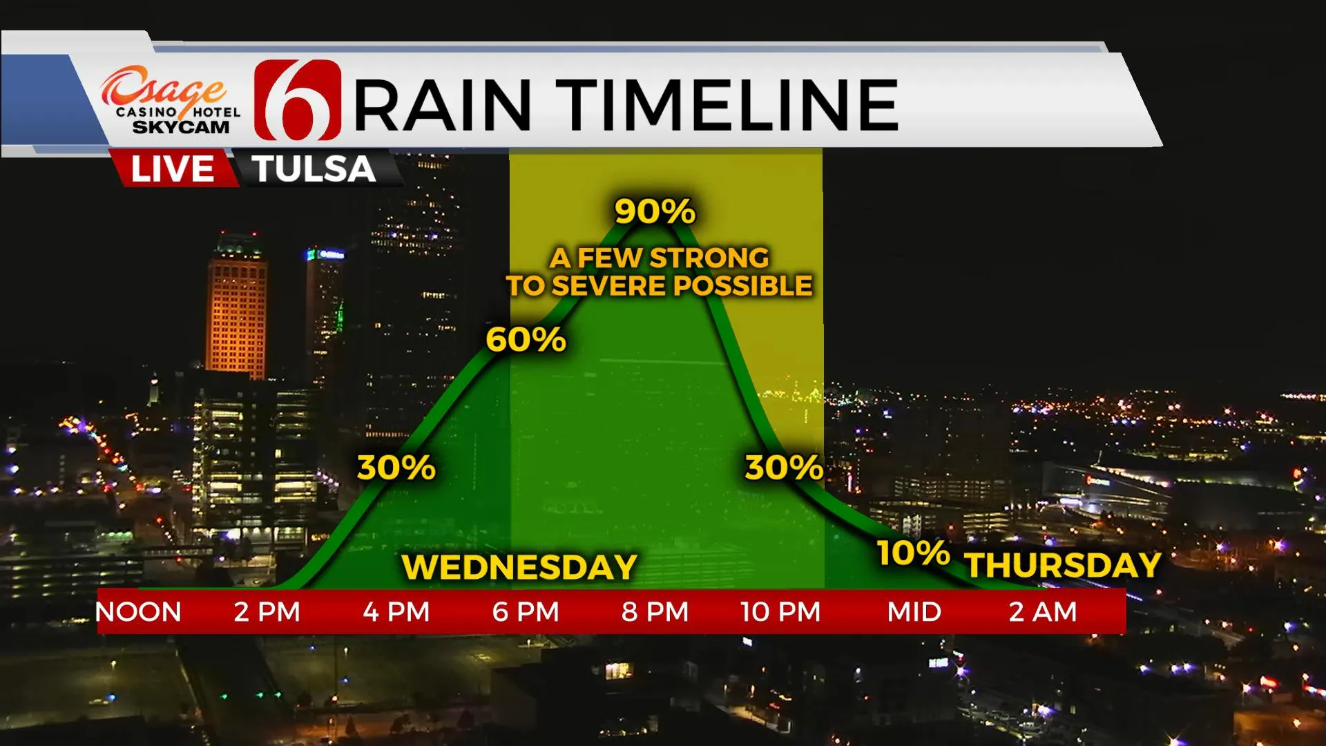
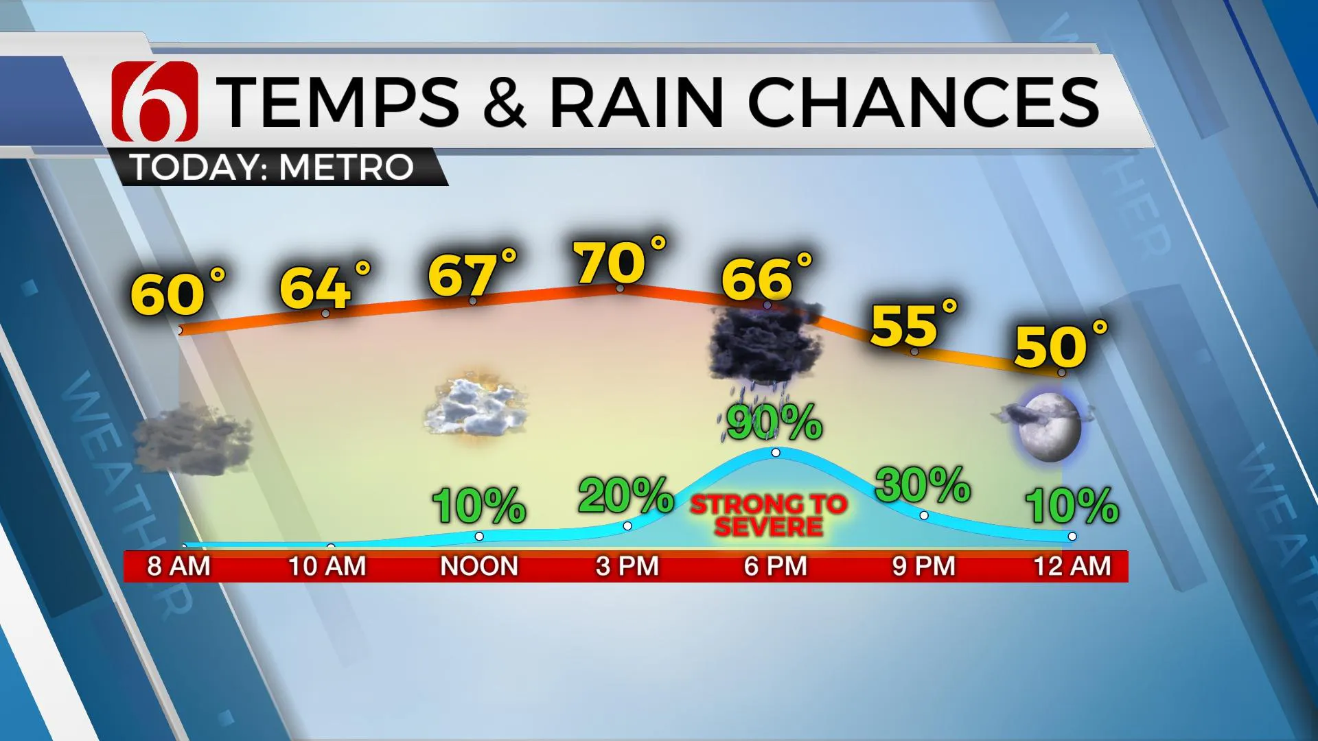
The front that stalled across northern OK last night has mostly become diffuse. A few light showers or even a pocket of drizzle will be possible for the early hours as moisture returns with south winds increasing across the area, but the probability remains very low. A strong cold front will move into the area tonight coupled with a moderately strong upper-level trough supporting thunderstorms, including the threat for a few strong to severe storms. The primary threat should be damaging winds and some small hail. The tornado threat is limited and mostly to the southwest of our immediate area but we're always watching for any signals as the line nears the area. The timing of the system appears to have increased some compared to previous data but not much. A few showers and storms will attempt to develop by early afternoon, but the layer of warm air aloft should suppress most activity across Eastern OK until the surface front nears the area with the main window for thunderstorms from 6 p.m. to 11 p.m. This system should be exiting far southeastern OK into western Arkansas between 9 p.m. and 11 p.m. Blustery northwest winds from 15 to 30 mph will occur behind the departing system overnight through most of Thursday with Thursday morning lows in the lower 40s and afternoon highs in the upper 50s and lower 60s with sunshine. Another upper-level wave should cross the central plains later Thursday evening into early Friday with another surge of colder air. A few spotty showers will be possible overnight Thursday into pre-dawn Friday with no impact. Northwest winds will also remain Friday with morning lows in the upper 30s to lower 40s and afternoon highs in the mid to upper 50s with more sunny sky.

A surface ridge of high pressure is expected to center across northeastern OK Friday afternoon and evening bringing clear sky and light winds into early Saturday morning with some locations dropping into the upper 20s and lower to mid-30s. Saturday afternoon highs will reach the mid to upper 50s with a return of south winds by afternoon and evening as the next system nears the central plains bringing yet another front across Oklahoma Sunday midday to afternoon. The atmosphere should be too dry to support any precipitation with the Sunday front, but another reinforcing shot of chilly weather will arrive early next week before gradually warming Tuesday and Wednesday before the next front by the middle of next week.

Thanks for reading the Wednesday morning weather discussion and blog.
Have a super great day!
Alan Crone
KOTV
If you’re into podcasts, check out my daily weather update below. Search for NewsOn6 and ‘Weather Out The Door’ on most podcast providers, including Apple, Stitcher, Tune-In and down below on Spotify.

More Like This
November 10th, 2021
June 21st, 2023
June 19th, 2023
June 13th, 2023
Top Headlines
December 14th, 2024
December 14th, 2024
December 14th, 2024
December 14th, 2024


