

Severe Weather Threats, Flood Watches
Rounds of rain and storms are likely on Wednesday morning before severe weather threats move in later in the day, into the overnight hours.Wednesday, May 4th 2022, 5:42 am
TULSA, Oklahoma -
Update 9:35 a.m. 5/4/2022:
Heavy thunderstorms continue moving ENE at 30 mph on Wednesday morning.
According to meteorologist Alan Crone, areas in the path of this storm could produce extremely heavy rainfall.
Alan crone says some areas may see penny, to quarter-sized hail.

Update 8:24 a.m. 5/4/2022:
A Severe Thunderstorm Warning has been issued for Rogers, Tulsa and Wagoner counties until 9 a.m.
According to the national weather service, the storm has the potential to produce quarter-sized hail, and could damage vehicles.
Meteorologist Alan Crone says the storm is currently moving northeast at around 35 mph.
---
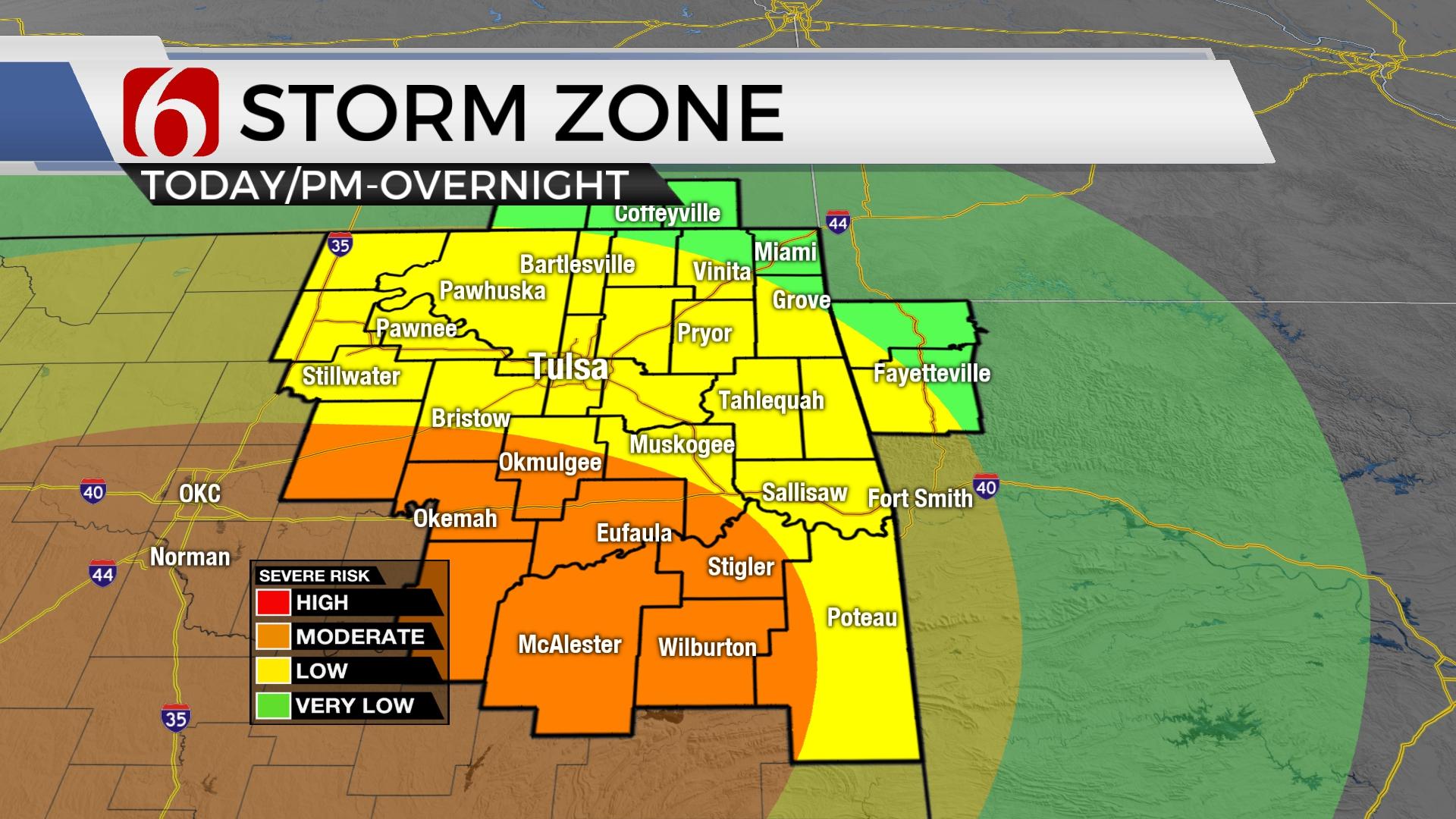
Rounds of rain and storms are likely on Wednesday morning before severe weather threats move in later in the day, into the overnight hours.
Click Here To See The Latest Weather Warnings And Watches
Here are the details from News On 6 Meteorologist Alan Crone:

Scattered showers and storms will attempt to develop for the next few hours across portions of northeastern OK and the surrounding vicinity. These storms may eventually produce hail and heavy rainfall, but the overall severe weather threat will be limited.
Click Here To See The Latest Weather Warnings And Watches
A warm front is likely to remain positioned south of the region Wednesday morning, but near the I-40 corridor later tonight. The position of this boundary could change depending upon the amount and duration of the activity this morning and midday. Later this afternoon and early evening, as the main upper-level low draws closer to the region, storms are likely to develop across far western OK ahead of a dry line. Storms will become severe with all modes of severe weather possible, including large hail, damaging winds, and tornadoes. Cells near the warm front may have a higher likelihood of significant severe weather if updrafts latch onto the warm side of the front. These storms will then move east to northeast during the late evening hours producing significant severe weather and extremely heavy rainfall. Additional storms further north are likely and may also be severe with all modes, but the higher likelihood for significant weather remains near this warm front. After midnight, additional storms are likely to develop as a surface cold front slowly moves eastward with at least one complex of severe storms developing capable of heavy rainfall, hail, and embedded circulations and damaging winds. This activity will continue through the overnight hours and may impact portions of eastern OK overnight into early Thursday morning.

Thursday midday to afternoon the potential for one more round of storms will exist near or east of highway 69 before the front and upper trough finally clear the state. These could also be severe across extreme eastern OK for a short period Thursday.
The pattern brings pleasant weather by Thursday evening into Friday. Warm and dry weather will arrive this weekend with highs Saturday reaching the lower 80s and Sunday into the upper 80s to the lower 90s.

Thanks for reading the Wednesday morning weather discussion and blog.
Have a super great day. Please remain aware of your weather surroundings.
Alan Crone
KOTV
If you’re into podcasts, check out my daily weather update. Search for NewsOn6 and ‘Weather Out The Door’ on most podcast providers, including Spotify, Stitcher and Tune-In, or Click Here to listen on Apple Podcasts.

Get The Daily Update!
Be among the first to get breaking news, weather, and general news updates from News on 6 delivered right to your inbox!
More Like This
May 4th, 2022

June 21st, 2023

June 19th, 2023

June 13th, 2023
Top Headlines

December 12th, 2024

December 12th, 2024

December 12th, 2024
