

Another Hot Weekend Approaching
Another day of hot and humid weather is expected across Green Country. across Green Country.Thursday, August 11th 2022, 6:56 am
TULSA, Okla. -
Another day of hot and humid weather is expected across Green Country.
Here are the details from News On 6 Meteorologist Alan Crone:
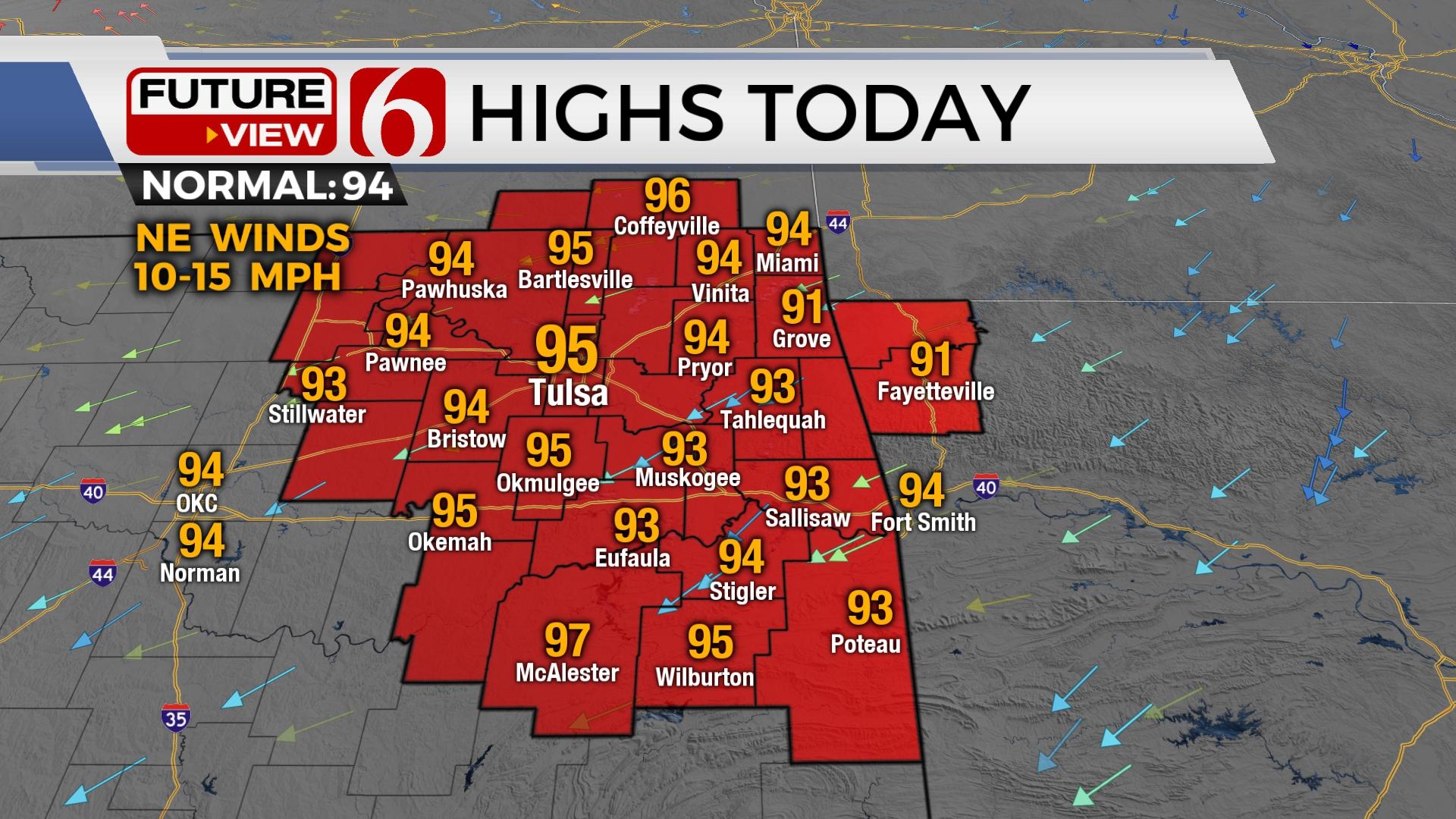
A pleasant morning brings another warm and sunny afternoon with highs near seasonal averages. Lower humidity this afternoon should reduce the heat index values. A hot weekend is expected before our next system nears the state by the middle of next week.

A weak boundary moved across the area yesterday bringing slightly drier air. This drying component continues this morning and will bring pleasant morning lows, both today and especially Friday morning. The dryer air also supports another warm to toasty afternoon, but with no significant heat index values this afternoon. We’ll expect lower to mid-90s today, but the drier air may lead to some locations slightly exceeding the forecast highs a degree or two. Northeast winds from 5 to 15 mph with full sunshine can promote ozone growth in the lower atmosphere in this pattern. Another Ozone alert will be in effect today for both the Tulsa and OKC metropolitan areas.

The center of the midlevel ridge of high pressure is expected over the state by Sunday into early next week before sliding southwest Tuesday as a powerful upper-level trough across the Hudson Bay region of Canada deepens and moves southeast. The impact will be to bring a cool, Canadian airmass across the upper midwestern U.S. with significant cooling in these areas. A cold front should arrive across our area either Tuesday or Wednesday with some shower and storm chances for a few days. The truly cooler air will remain well northeast, but the presence of clouds and the potential for showers and storms will result in a notable reduction in temperatures for northern Oklahoma. After highs from 100 to 103 early next week, daytime highs could drop into the 80s Wednesday and Thursday. This respite will be short-lived with another robust warm-up likely by the end of next week.

I wrote about the Atlantic hurricane season yesterday and the lack of activity the past few weeks. This is not unusual for a slow start. So far, the season has experienced three named storms and no actual hurricanes in the basin. The official NOAA updated outlook calls for 14 to 20 named storms, and 6 to 10 of those could become hurricanes. La Nina conditions are expected through the season and weather patterns across western African weather appear to be increasing production of weather disturbances and storms. All this points toward the potential for more tropical development during the next month.
Thanks for reading the morning weather discussion and blog and listening to the morning podcast.
Have a super great day!
Alan Crone
KOTV
If you’re into podcasts, check out my daily weather update. Search for NewsOn6 and ‘Weather Out The Door’ on most podcast providers, including Spotify, Stitcher and Tune-In, or Click Here to listen on Apple Podcasts.

Get The Daily Update!
Be among the first to get breaking news, weather, and general news updates from News on 6 delivered right to your inbox!
More Like This
August 11th, 2022

June 21st, 2023

June 19th, 2023

June 13th, 2023
Top Headlines

December 14th, 2024

December 14th, 2024

December 14th, 2024

December 14th, 2024