

Nearing Record Highs Before The Next Cold Front
More heat is expected on Tuesday as the sunshine and south winds continue.Tuesday, September 20th 2022, 6:42 am
TULSA, Okla. -
More heat is expected on Tuesday as the sunshine and south winds continue.
Here are the details from News On 6 Meteorologist Alan Crone:

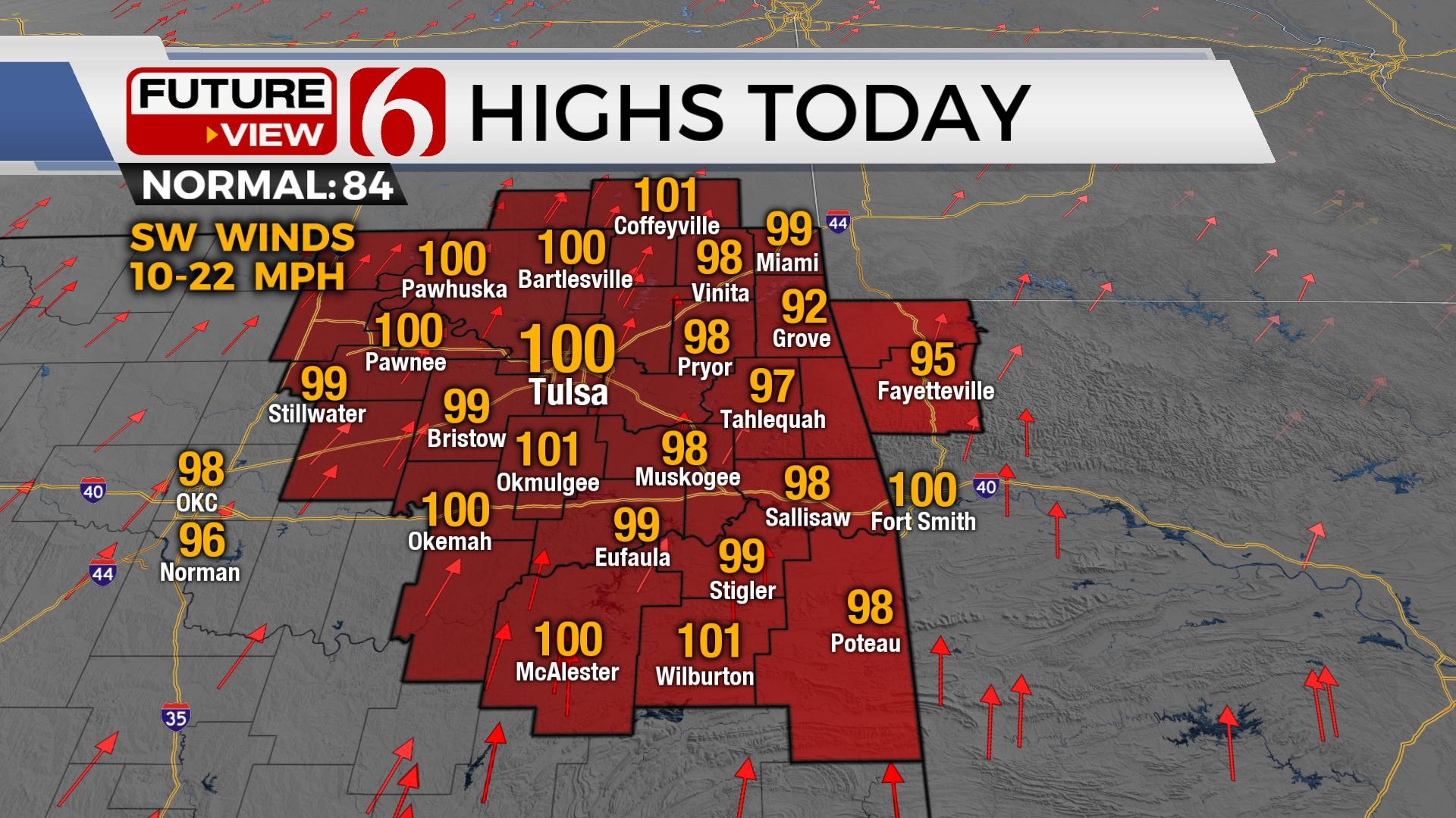
We’re two days away from the Autumnal Equinox. Yet very summerlike weather remains for most of the week, including the possibility of record highs both Tuesday and Wednesday before the first of two cold fronts move across the state bringing some minor and short-lived relief from the heat. The first arrives Thursday morning and the second Sunday. Any showers with the Thursday morning front will stay a hair north of our immediate area. Rain and storm chances will accompany the Sunday cold front, but probabilities remain low as most data support higher chances only across extreme northeastern OK and southern Kansas. Temps will drop Thursday for at least the northern half of the area but will quickly rebound Friday and Saturday, moving back above normal. Temperatures behind the Sunday front will be more noticeable Monday and Tuesday of next week with morning lows in the 50s and afternoon highs in the lower to mid-80s.

Slightly drier air will be likely later this afternoon. This allows surface temps to climb a few degrees higher compared to yesterday, but also decreases the heat index value. This same scenario is likely Wednesday. South to southwest winds from 10 to 22 mph will be likely through Wednesday. Due to the ongoing drought and slowly drying vegetation, fire spread rates will be increasing through the next few days.

As mentioned above, the first front Wednesday evening into early Thursday brings cooler air into at least northern OK. There remain questions as to whether this cooler air will have any notable impact across the region south of I-40. Some of the hi-res data suggests a few showers and storms may be possible late Wednesday into early Thursday north of the OK-KS state line region. Even if this occurs, precip will remain north, but some clouds have a better chance of lingering Thursday also aiding in keeping highs in the upper 70s and lower 80s across northern Oklahoma. South winds quickly return Friday with temps rebounding into the mid to upper 90s by Saturday afternoon.

A strong upper-level trough will move across the northern high plains and upper Midwest this weekend while helping to bring the surface front south across Oklahoma Sunday. A few showers or storms may brush far northeastern OK during this period. The upper air flow behind the system will remain from the northwest for a few days next week keeping our area dry and pleasant with morning lows in the 50s and afternoon highs in the lower 80s.
Thanks for reading the Tuesday morning weather discussion and blog.
Have a super great day!
Alan Crone
KOTV
If you’re into podcasts, check out my daily weather update. Search for NewsOn6 and ‘Weather Out The Door’ on most podcast providers, including Spotify, Stitcher and Tune-In, or Click Here to listen on Apple Podcasts.

Get The Daily Update!
Be among the first to get breaking news, weather, and general news updates from News on 6 delivered right to your inbox!
More Like This
September 20th, 2022

June 21st, 2023

June 19th, 2023

June 13th, 2023
Top Headlines

December 11th, 2024

December 11th, 2024

December 11th, 2024

December 11th, 2024