

Blustery North Winds Remain
Blustery conditions are expected on Veterans Day after cooler temperatures returned to Green Country.Friday, November 11th 2022, 6:42 am
If you’re into podcasts or in a rush, check out my daily weather update. Search for NewsOn6 and ‘Weather Out The Door’ on most podcast providers, including Spotify, Stitcher and Tune-In, or Click Here to listen on Apple Podcasts.
TULSA, Okla. - Blustery conditions are expected on Veterans Day after cooler temperatures returned to Green Country.
Here are the details from News On 6 Meteorologist Alan Crone:

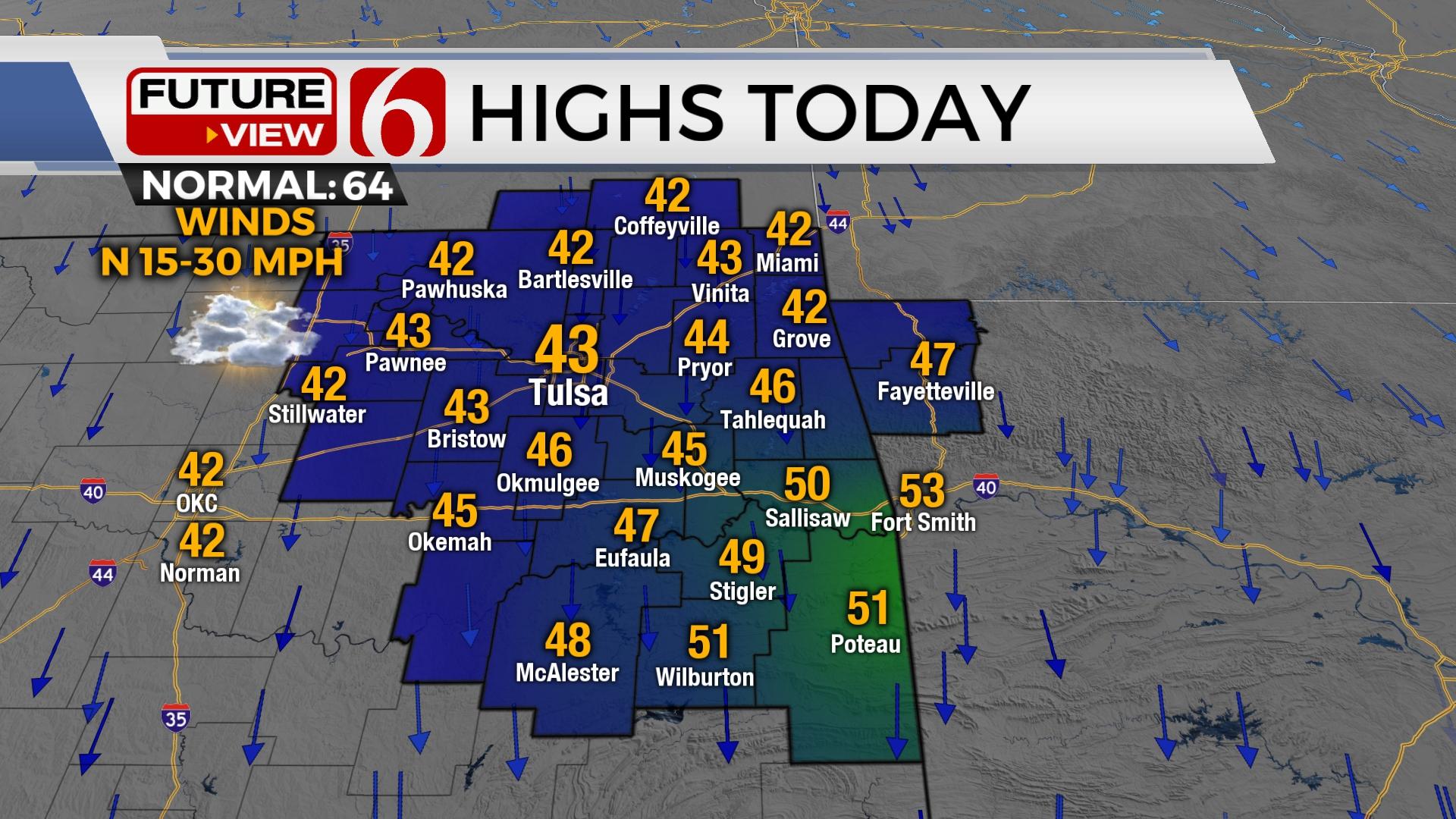
The front is located well south of the area on Friday morning. Scattered showers will quickly end with this current wave. As the air aloft becomes colder across northern Oklahoma this morning, most of the precap will quickly end. Gusty north winds will prevail from 15 to 30 mph for the day with afternoon highs in the lower 40s north and mid-40s south. Mostly to partly cloudy conditions are expected with a second wave nearing the area this evening across north Texas and southern Oklahoma. This should bring some additional scattered showers into the Red River Valley and part of southeastern OK this afternoon and exiting later tonight. A few showers may extend northward near the metro by Friday evening. I’ll include a low mention for the Tulsa metro with slightly higher probabilities across southern to east-central Oklahoma. The air aloft later tonight will be cold enough for a few snowflakes to mix down with scattered showers, mostly across extreme eastern Oklahoma and northwest Arkansas. This wave should exit our immediate area around midnight with clearing sky and cold weather for the weekend.

As clouds clear overnight, a hard freeze is likely on Saturday morning with many locations dropping into the lower and mid-20s. A Canadian ridge of high pressure nearby will keep highs in the mid to upper 40s Saturday with north winds at 10 to 15 mph along with abundant sunshine. Our next strong system nears the state Monday but will influence our weather Sunday with south winds and highs reaching the lower 50s. Sunday night into Monday rain is likely to develop as a strong upper-level system ejects from New Mexico across Oklahoma.

As the Monday system approaches the area, colder air aloft will overspread the state by midday into the afternoon. Rain will be likely with this system and attempting to change to or mix with snow in some locations. If the upper air system becomes more of a closed low, a significant swath of wet snow will be possible across part of the state as the column of cold air attempts to influence temperature at the very lowest levels. The overall pattern is favorable for accumulating snow but the question regarding the exact track and intensity of the upper-level low and its impact on low-level thermal probabilities will determine the exact precipitation type and location. The system will exit the region Monday late into pre-dawn Tuesday. Another strong cold front is likely to arrive by the end of next week bringing even colder air for next weekend.

Thanks for reading the Friday morning weather discussion and blog.
Have a super great day!
Alan Crone
KOTV

Get The Daily Update!
Be among the first to get breaking news, weather, and general news updates from News on 6 delivered right to your inbox!
More Like This
November 11th, 2022

June 21st, 2023

June 19th, 2023

June 13th, 2023
Top Headlines

December 12th, 2024

December 12th, 2024

December 12th, 2024

December 12th, 2024