

Preparing For A Cold Air Outbreak
TULSA, Okla. - Get ready to bundle up, an arctic front will soon bring frigid temperatures to Green Country.Tuesday, December 20th 2022, 7:14 am
TULSA, Okla. -
If you’re into podcasts or in a rush, check out my daily weather update. Search for NewsOn6 and ‘Weather Out The Door’ on most podcast providers, including Spotify, Stitcher and Tune-In, or Click Here to listen on Apple Podcasts.
TULSA, Okla. - Get ready to bundle up, an arctic front will soon bring frigid temperatures to Green Country.
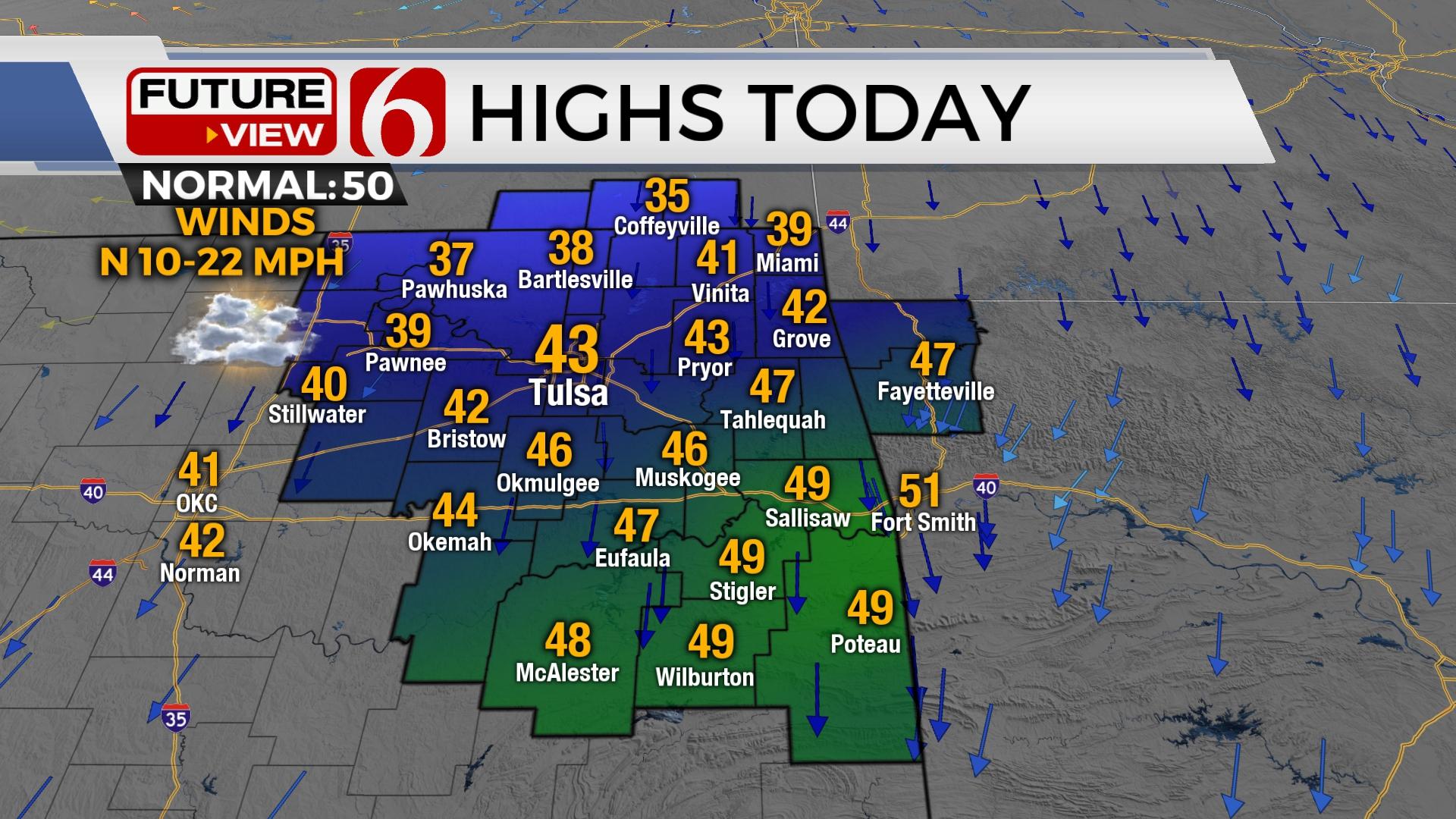
Here are the details from News On 6 Meteorologist Alan Crone:

A weak front arrives on Tuesday across northern sections of the state before stalling and lifting slightly northward Wednesday before the much-advertised cold front arrives Thursday morning. Bitterly cold air and powerful winds roll across the state behind the front with some areas of snowfall. This cold air mass will remain through the weekend before moderating early next week. Highs on Tuesday will stay in the lower 40s north and upper 40s south.

As is normally the case, the actual arrival of the arctic front will be faster than most model data depictions. The leading edge will blast across northwestern Oklahoma and south-central Kansas around midnight to 3 a.m. and enter the Tulsa metro before sunrise Thursday morning. The cold air will quickly race southeast covering all the area by mid-morning. As the front passes, some spotty drizzle or light showers will quickly transition to some light freezing rain and then quickly into snow. The potential for a flash freeze directly behind the front is possible. Some slick spots may quickly develop with freezing drizzle on elevated surfaces before quickly changing to snow. The better areas for snow accumulation will be along and north of the I-44 corridor. Accumulations from one to near three inches will be possible along and north of I-44, with higher amounts along the OK-KS state line region and also across northwestern Arkansas. The Tulsa metro will be in the one-to-three-inch possibilities.

Powerful northwest winds will develop directly behind the frontal intrusion and will increase speeds from 25 to 45 mph during the morning to afternoon as the cold air advances southeast. Some gusts nearing 50 mph will be likely. Stronger gusts, possibly nearing 60 mph will be possible along and west of I-35. The projection of these strong northwest winds and the possibility of snow present the opportunity for near blizzard-like conditions Thursday with blowing snow and reducing visibilities. The National Weather Service definition of a blizzard precludes any specific amount of snow and is defined as blowing or falling snow with winds at least 35 mph reducing visibility to a quarter mile or less for at least three hours.
Temperatures will plummet Thursday morning. By midday to afternoon readings in the single digits to lower teens will be common across the area. The strong northwest winds will create wind chill values from -10 to -20 with a few readings approaching -30. By late Thursday night into Friday morning, low temps will reach the -4 to +4 range across northeastern OK with wind chill values from -10 to -25. Friday afternoon highs should stay in the 10 to 15 range with northwest winds at 15 to 30 mph for most of the day before decreasing speeds by Friday evening. A wind chill watch is currently underway for the area. This means wind chills from -20 to -30 will be possible during the cold air outbreak. These types of wind chills can cause frostbite on exposed skin in as little as 30 minutes.

Christmas Eve morning starts at eight degrees with highs in the lower 20s. A weak upper-level wave may bring a few small areas of light snow occasionally by afternoon with no additional accumulation likely. This chance remains low. Sunday, Christmas Day features lows near 10 and highs in the lower 30s.
The period from Thursday through Saturday could result in life-threatening cold and wind chill values.
Thanks for reading the Tuesday morning weather discussion and blog.
Have a super great day!
Alan Crone
KOTV

Get The Daily Update!
Be among the first to get breaking news, weather, and general news updates from News on 6 delivered right to your inbox!
More Like This
December 20th, 2022

June 21st, 2023

June 19th, 2023

June 13th, 2023
Top Headlines

December 11th, 2024

December 11th, 2024

December 11th, 2024

December 11th, 2024