

The Deep Freeze Remains
Frigid temperatures continue on Friday after a winter storm brought snow and ice to Green Country on Thursday.Friday, December 23rd 2022, 7:44 am
If you’re into podcasts or in a rush, check out my daily weather update. Search for NewsOn6 and ‘Weather Out The Door’ on most podcast providers, including Spotify, Stitcher and Tune-In, or Click Here to listen on Apple Podcasts.
Frigid temperatures continue on Friday after a winter storm brought snow and ice to Green Country on Thursday.
TULSA, Okla. - Here are the details from News On 6 Meteorologist Alan Crone:

The bitterly cold weather will remain for most of the weekend but with some moderation by Christmas as highs reach the lower 30s, slightly above freezing for the northern third of the area with some upper 30s near 40s across southeastern Oklahoma. A fast clipper arrives from the northwest Sunday evening that may produce a small area of light freezing rain across extreme northeastern Oklahoma and southeastern Kansas. The upper air pattern changes by the middle of next week supporting a robust warming trend with above-normal highs Wednesday through Friday. Shower and storm chances return by the end of next week.

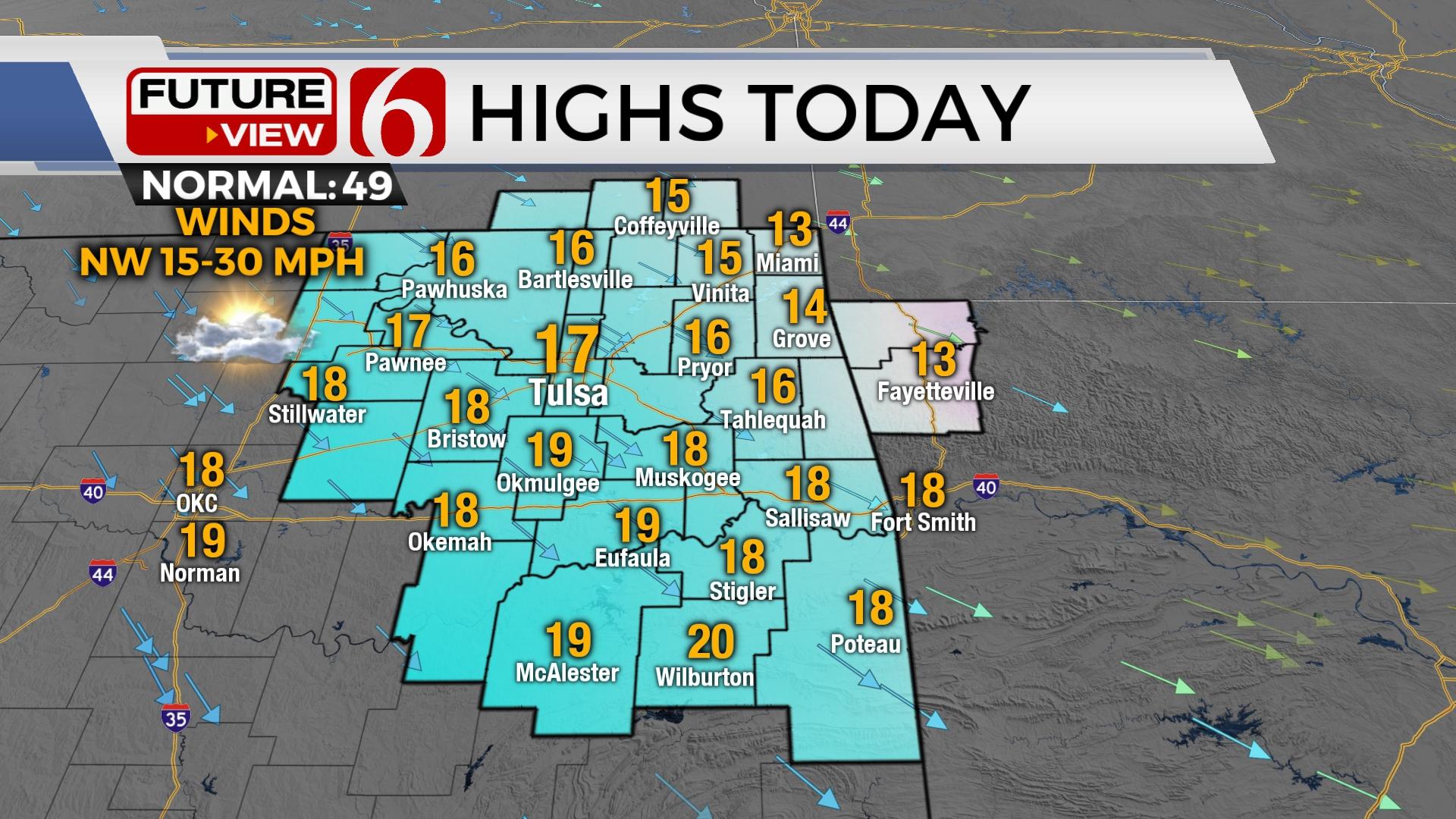
The powerful front and storm system that brought some snow to part of the area on Thursday will keep us very cold for most of the weekend. Morning temperatures are starting near and below zero across the northern sections of the state with wind chill values from -15 to -30. A wind chill warning will remain until at least noon today and may be replaced with another wind chill advisory continuing into part of Saturday morning. Afternoon highs will stay in the mid to upper teens north and lower 20s south today. Northwest winds from 15 to 30 mph will remain until decreasing some later this evening. We’ll start with mostly sunny conditions but there will be a few clouds later today arriving from the west. Some local flurries may occur today surrounding the lakes.

Christmas Eve morning temps will remain in the single digits with afternoon highs in the mid to upper 20s. We’ll break above freezing Christmas Day with highs in the lower to mid-30s north before the fast clipper arrives from the northwest. Most data keep this system east of the metro, but the trajectory could easily slide westward in the data over the next few days. This system is not a major event but may still produce some slick spots late Sunday evening into predawn Monday across the far northeastern sections of the state. The chance for this system will remain relatively low for today’s outlook.

The upper pattern currently from the northwest changes to the southwest by the middle of next week. This will bring strong south winds across the state Wednesday through the end of next week before a storm system nears with shower and storms chances into the weekend.
We’ll encourage you to remain aware of roadways this morning. Residual slick spots will be possible.
Thanks for reading the Friday morning weather discussion and blog.
Have a super great day!
Alan Crone
KOTV


Alan Crone
At the first hint of storms, a young Alan Crone would start watching from the big front porch of his parents' home in McAlester.

Get The Daily Update!
Be among the first to get breaking news, weather, and general news updates from News on 6 delivered right to your inbox!
More Like This
December 23rd, 2022

June 21st, 2023

June 19th, 2023

June 13th, 2023
Top Headlines

March 2nd, 2025

March 2nd, 2025

March 2nd, 2025

March 2nd, 2025