

System Nearing Soon
Expect a chilly start to the day before slightly warmer temperatures arrive toward the afternoon hours.Thursday, January 5th 2023, 6:02 am
If you’re into podcasts or in a rush, check out my daily weather update on Spotify or Apple Podcasts. You can also search for NewsOn6 and ‘Weather Out The Door’ on most podcast providers, including Stitcher and Tune-In.
TULSA, Okla. - Expect a chilly start to the day before slightly warmer temperatures arrive toward the afternoon hours.
Here are the details from News On 6 Meteorologist Alan Crone:

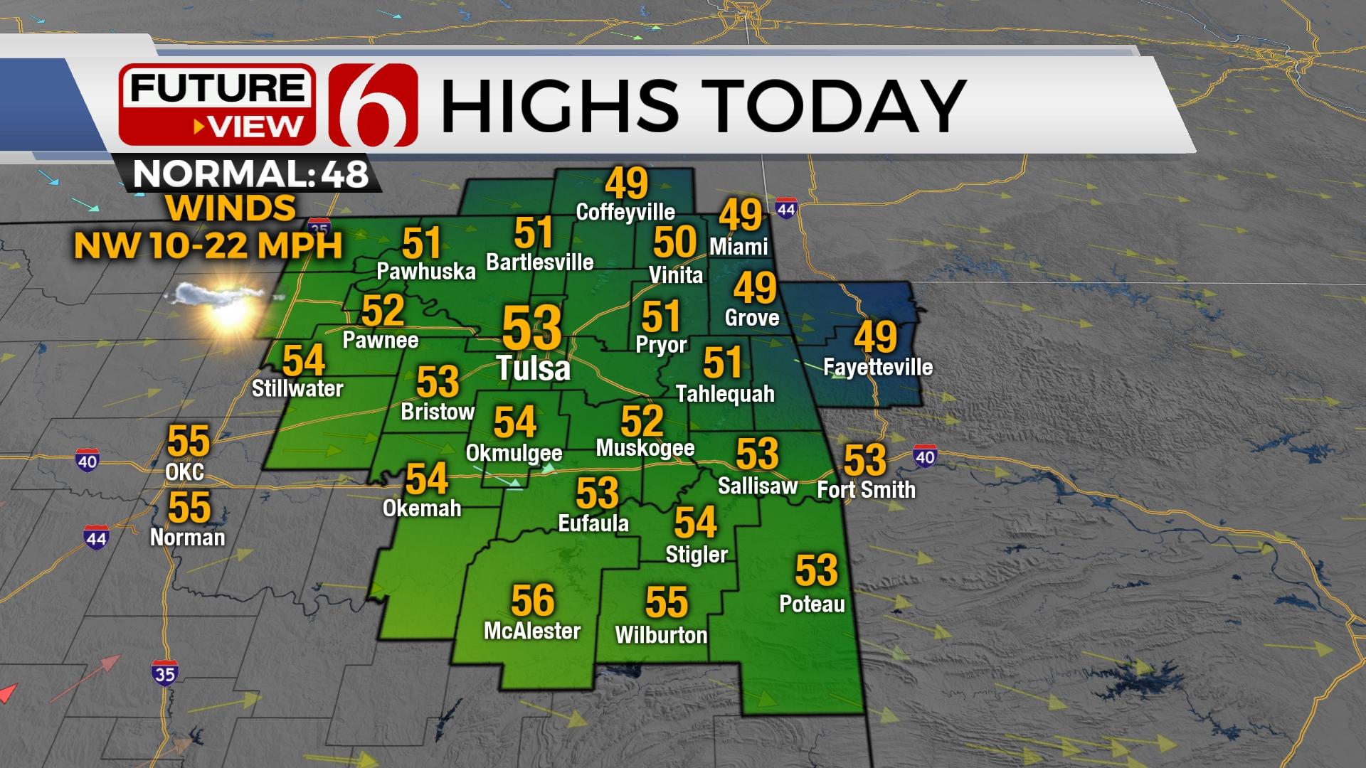
We'll start with temps in the upper 20s and lower 30s on Thursday morning with afternoon highs in the lower 50s north and upper 50s south. Winds remain mostly from the northwest on Thursday as speeds from 10 to 20 mph but will increase speeds from the south Friday before our next system quickly moves across the region. No major impacts are expected with this front. Another system nears by next Tuesday but should also have minimal impacts on sensible weather. The overall pattern will remain active with several upper-level systems nearing the state. A storm system nearing by Wednesday into Thursday may bring storm chances to part of the state, but the data remain inconsistent.

Thursday will be a relatively nice afternoon with mostly sunshine and pleasant weather with occasionally breezy northwest winds. Later tonight, as the fast-moving upper system nears the plains, a surface low is likely to rapidly develop across western Oklahoma and move eastward by evening. The southeast wind flow into the system should support clouds, gusty to strong southeast winds, and afternoon highs reaching the lower 60s. Most hi-res data support some showers on Friday morning through midday, but the dry low levels may keep these from reaching the surface. The surface low ejects northeast late Friday night with an associated cold front quickly advancing southeast. The lack of quality and deep moisture suggests any precipitation will be very spotty and very light, if any in your area. I'll keep only low chances for this system, and mostly from Friday evening into pre-dawn Saturday.

Temps Saturday will remain cool with morning lows in the upper 30s and lower 40s. Afternoon highs will stay in the lower 50s. Sunday features some clouds and south winds returning with highs in the lower 50s. Another one-day warm-up is likely Monday with another gusty south wind at 15 to 30 mph before a front brings slightly cooler air Tuesday. This one should pass the area dry. A stronger system may be near Wednesday evening that could produce showers and storms. I’ll have more on this on Friday.

Thanks for reading the Thursday morning weather discussion and blog.
Have a super great day!
Alan Crone
KOTV

Get The Daily Update!
Be among the first to get breaking news, weather, and general news updates from News on 6 delivered right to your inbox!
More Like This
January 5th, 2023

June 21st, 2023

June 19th, 2023

June 13th, 2023
Top Headlines

December 11th, 2024

December 11th, 2024

December 11th, 2024

December 11th, 2024