

Blustery Weather Returns Thursday
More warm weather is expected on Wednesday before some colder temperatures return.Wednesday, January 11th 2023, 7:23 am
If you’re into podcasts or in a rush, check out my daily weather update. Search for NewsOn6 and ‘Weather Out The Door’ on most podcast providers, including Spotify, Stitcher and Tune-In, or Click Here to listen on Apple Podcasts.
TULSA, Okla. - More warm weather is expected on Wednesday before some colder temperatures return.
Here are the details from News On 6 Meteorologist Alan Crone:

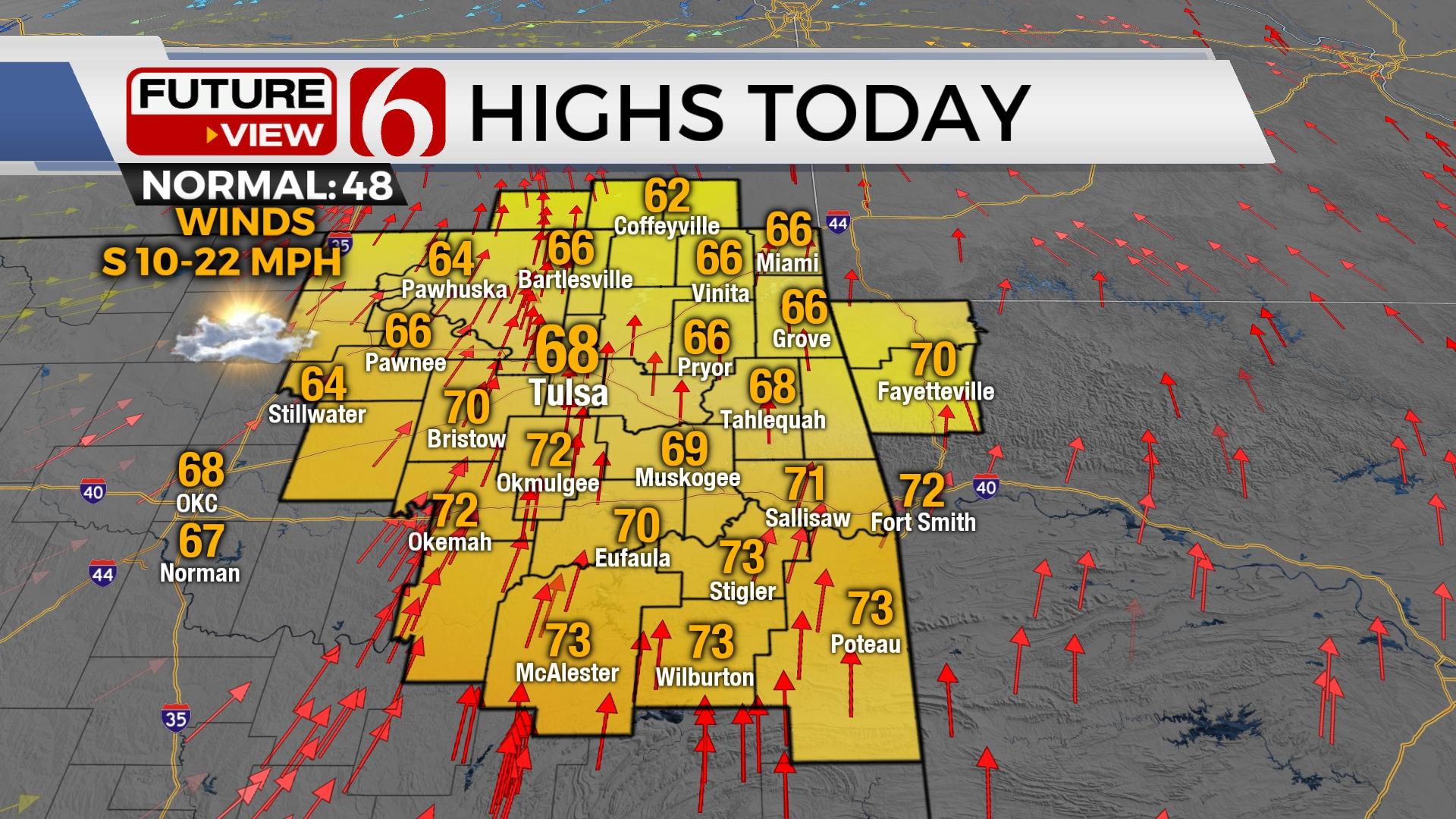
Another above-normal afternoon is expected with highs in the upper 60s and lower 70s before a strong cold front rolls into the area late Wednesday night. This brings the return of cooler, near-normal temperatures for the latter half of the week. Shower and storm chances tonight will be very limited and across extreme eastern sections of the state. Another strong-looking system arrives early next week with a rather amplified pattern continuing for the foreseeable future. Gusty afternoon and evening winds combined with relatively low humidity will increase the fire spread rates across the central and eastern Oklahoma region this afternoon.

We continue with a progressive pattern across most of the country, including the southern and central plains states. But these systems have been arriving so quickly, that low-level moisture has mostly been shunted eastward as they approach Oklahoma. This will probably be the case again tonight. We’ll keep a small window for a few isolated storms developing across far eastern sections with higher chances across the state line into western Arkansas. We’ll remove the mention for showers in the metro. The strong winds aloft would support the potential for any mature storm becoming strong to severe. As the system moves quickly east, a few areas of light rain morphing to some snow showers will develop across southern Kansas into the mid-Missouri Valley overnight into early Thursday morning. Any wintry impacts will remain north of our immediate areas of concern while dropping across northwestern Arkansas early Thursday morning. Colder, blustery weather returns tomorrow with strong northwest winds and highs in the mid to upper 40s and wind chills in the 20s. Temps drop into the 20s Friday morning with afternoon highs remaining in the upper 40s with sunshine and light winds. The south winds return this weekend with increasing daytime highs in the upper 50s Saturday and mid to upper 60s Sunday. Tightening pressure gradients should support south winds from 20 to 30 mph Sunday ahead of the next fast moving system Sunday night into early Monday morning. Once again, we’ll deal with a race between the arrival of the upper-level system and low-level moisture. At this point, shower and storm chances remain low, but not zero.

Thanks for reading the Wednesday morning weather discussion and blog.
Have a super great day!
Alan Crone
KOTV

Get The Daily Update!
Be among the first to get breaking news, weather, and general news updates from News on 6 delivered right to your inbox!
More Like This
January 11th, 2023

June 21st, 2023

June 19th, 2023

June 13th, 2023
Top Headlines

December 11th, 2024

December 11th, 2024

December 11th, 2024

December 11th, 2024