Active Weather Brings More Storm Chances
Oklahoma Weather Forecast: Bookmark this page and refresh it often for the latest forecast and daily updates.Wednesday, May 1st 2024, 10:40 pm
TULSA, Okla. -
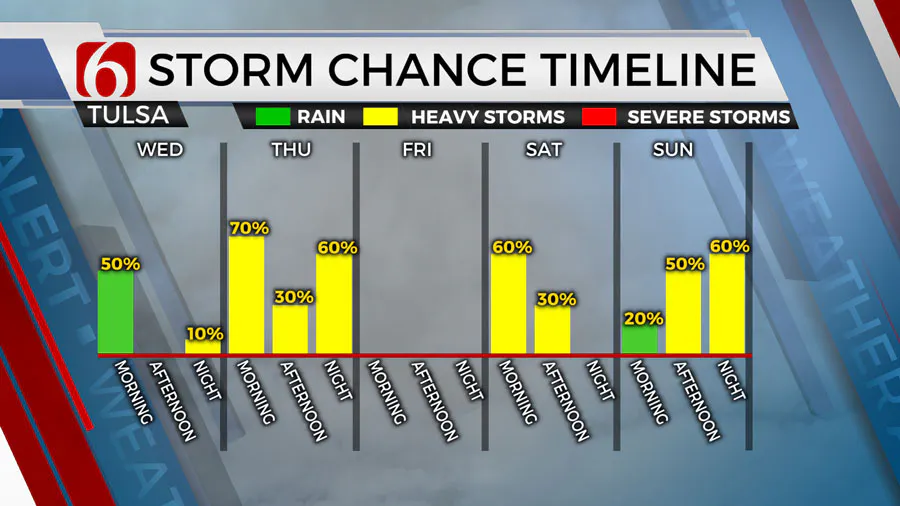
Thursday morning there may be two batches of storms. One larger area is expected across southeastern OK along the Red River Valley, Texoma region, extending into part of northern Texas. Another area is possibly far northern OK. Higher chances remain to the south, but we’ll keep a decent mention near northern OK for early Thursday morning.

As the front progresses southeast, additional storms are likely to develop by afternoon and evening. The upper air flow will be relatively weak but some strong to severe storms will remain possible Thursday.
A mitigating factor will be the storms along the Red River Thursday morning. If these last longer than anticipated, the moisture flow into the developing frontal boundary will be disrupted.
Storm chances will remain regardless of this scenario but the threat of strong to severe storms may be mitigated Thursday.
What will the weather be like this weekend in Oklahoma?
As the front moves southeast, we’ll see a minor break in storm activity Friday with morning lows in the upper 50s and afternoon highs reaching the mid to upper 70s with north winds from 15 to 25 mph.
This front is expected to stall and begin lifting northward Saturday as another wave approaches from the west.
We’ll expect a few showers and storms developing late Friday into the overnight periods into early Saturday with this process.
Higher chances for storms should also arrive early Saturday morning as a storm complex is likely to develop across southwestern Kansas Friday night and track into part of northern OK Saturday.
Additional storm chances will return Sunday into Monday, a much stronger upper-level trough is likely to approach the region from the southwest.
What will the weather be like next week in Oklahoma?
Storm chances are likely to return for part of Sunday with gusty south winds and highs in the mid to upper 70s. A few of the storms may be strong to severe Sunday with higher threats across the western half of the state.
By Sunday evening into Monday, a powerful upper-level trough is drawing closer to the state and will be increasing some severe weather parameters Monday. The system may also encounter an increasing layer of warm air aloft that may initially suppress some storm activity early to midday Monday.
By Monday late afternoon and evening, strong to severe storms will be possible as lift from the system is maximized. Some changes are likely to this portion of the forecast and will be refined in the coming days.
Outages Across Oklahoma:
Northeast Oklahoma has various power companies and electric co-operatives, many with overlapping areas of coverage. Below is a link to various outage maps.
Indian Electric Cooperative (IEC) Outage Map
Oklahoma Association of Electric Cooperatives Outage Map - (Note Several Smaller Co-ops Included)
The Alan Crone morning weather podcast link from Spotify:
https://open.spotify.com/episode/5j0ovActG8BZCOTqZQzrfU
The Alan Crone morning weather podcast link from Apple:
https://podcasts.apple.com/us/podcast/weather-out-the-door/id1499556141?i=1000646589555
Follow the News On 6 Meteorologists on Facebook!

More Like This
May 1st, 2024
May 2nd, 2024
May 2nd, 2024
Top Headlines
May 2nd, 2024


