Bitter Cold.
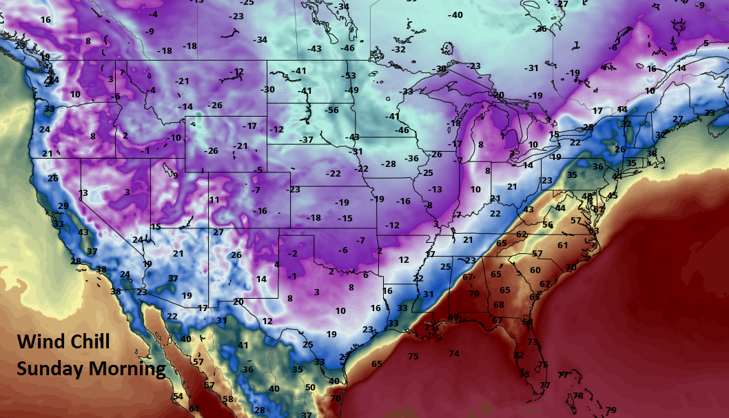
<p>Wind chill values will be into negative territory which is at a dangerous level for the Sunday morning time frame. Despite sunny skies, temperatures will be slow to warm over the next few days.</p>Saturday, December 17th 2016, 8:49 pm


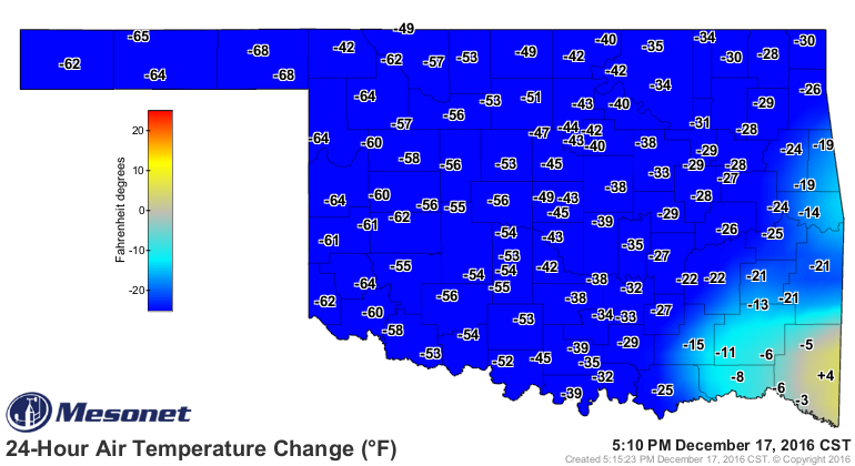
What a difference a day can make. Daytime highs yesterday were in the 70s and even some low 80s for our neighbors to the west. For Tulsa, the high temperature that will go into the record book for today will be 61, but that was at midnight. Since then temperatures have been falling along with strong northerly winds to make it feel even colder.
[img]
The wintry weather that has also developed late this afternoon and into the early night is quickly moving on eastward and will leave us with clear or clearing skies by Sunday morning. However, those gusty northerly winds will continue at 10-20 mph and together with temperatures dropping into the single digits will make for a brutally cold start to Sunday. For that reason, the good folks at the local NWS office have issued a dangerous wind chill advisory as we will be well into negative territory.
[img]
Despite sunny skies, temperatures will struggle to warm much for Sunday afternoon with brisk northerly winds gradually subsiding by afternoon and evening. Daytime highs in the teens to near 20 are about the best we can expect.
Clear skies and light winds together with some snow on the ground will make for an even colder start to the day Monday, but at least the winds will be light so the wind chill will not be as much of a factor. Even so, look for morning temperatures to be in the low single digits and would not be surprised if some of the colder valleys in N/NE OK drop into negative territory.
A light southerly wind on Monday will try to moderate temperatures somewhat, but it appears that we will not have full sun as some high level clouds will be moving overhead. As a result, have opted to keep temperatures below freezing through Monday as well.
As you can see on our forecast page, we will finally start to thaw during the day Tuesday with brisk southerly winds and just some high level cirrus clouds which should still allow temperatures to reach the 40s that afternoon. Wednesday will see another frontal boundary move across the state, but this is a Pacific cold front so just cooler air, not the bitterly cold air we are now experiencing. Also, this looks to be a dry system.
That will be followed by a return to gusty southerly winds by Friday which also looks to be the warmest day of this forecast cycle. Another cool front now looks to be moving through the state on Christmas Eve and may have some showers associated with it. This system will not be followed by arctic air either, but it will certainly be cooler that afternoon through Christmas Day.
Speaking of Christmas Day, the longer range guidance continues to be very problematic as there has been very little consistency from run to run nor from model to model. For now, will keep things dry and go with cooler than normal temperatures, but that is certainly subject to change.
Notice the 8-14 day outlook which will get us up to the end of the year suggests temperatures, on average, should be running above normal for that time period. That time period should also be more active with respect to at least some chances for precipitation.
[img]
[img]
In the meantime, stay tuned and check back for updates.
Dick Faurot

Get The Daily Update!
Be among the first to get breaking news, weather, and general news updates from News on 6 delivered right to your inbox!
More Like This
December 17th, 2016

April 15th, 2024

April 12th, 2024

March 14th, 2024
Top Headlines

April 26th, 2024

April 26th, 2024
April 26th, 2024

April 26th, 2024
