Severe Weather Threats On Tuesday For Green Country
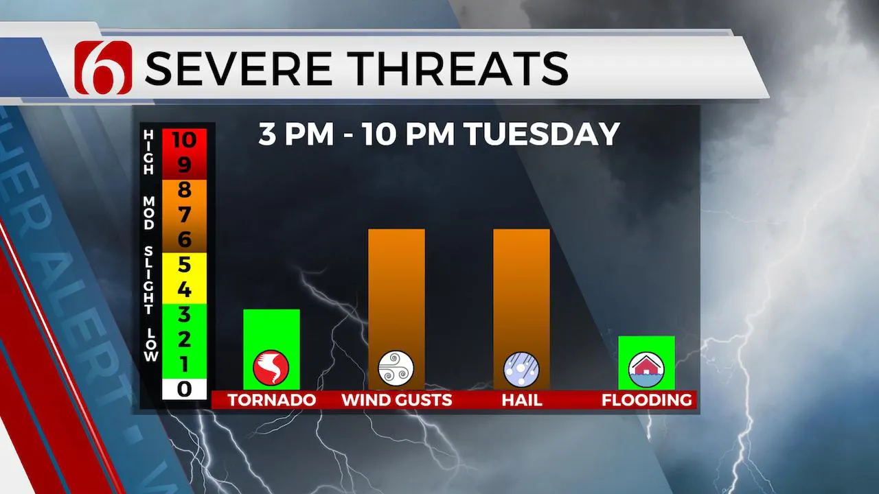
This line is expected to produce damaging winds, hail and heavy rainfall. A tornado threat will be possible, but the higher likelihood is for damaging winds and hail.Tuesday, April 28th 2020, 5:48 am
A few showers or storms can’t be ruled out this morning across southeastern OK, but much higher chances will arrive by this afternoon across northeastern OK as a strong upper level system moves across the central plains while a surface cold front moves quickly southward. The net impact will be a developing line of thunderstorms, with severe weather threats, moving across northern OK early afternoon and exiting southeastern OK tonight. This line is expected to produce damaging winds, hail and heavy rainfall. A tornado threat will be possible, but the higher likelihood is for damaging winds and hail. This line of thunderstorms may still be intact Wednesday morning as it moves across southeast Texas and into the Gulf of Mexico by Wednesday midday. Behind this system, pleasant weather will remain for the rest of the week as a mid-level ridge of high pressure brings warmer weather into the state by Friday and Saturday. We’ll be nearing the upper 80s to lower 90s before our next strong looking system nears by Sunday into early next week.

This morning we may see a small flare-up of a few showers or storms across far southern OK. Overnight a few storms attempted to form along the Red River Valley but mostly remained across north TX near the DFW metroplex. A disturbance from this area is moving eastward this morning and may trigger a few storms to our south. Higher chances, likely probabilities will arrive later this afternoon with the main system.

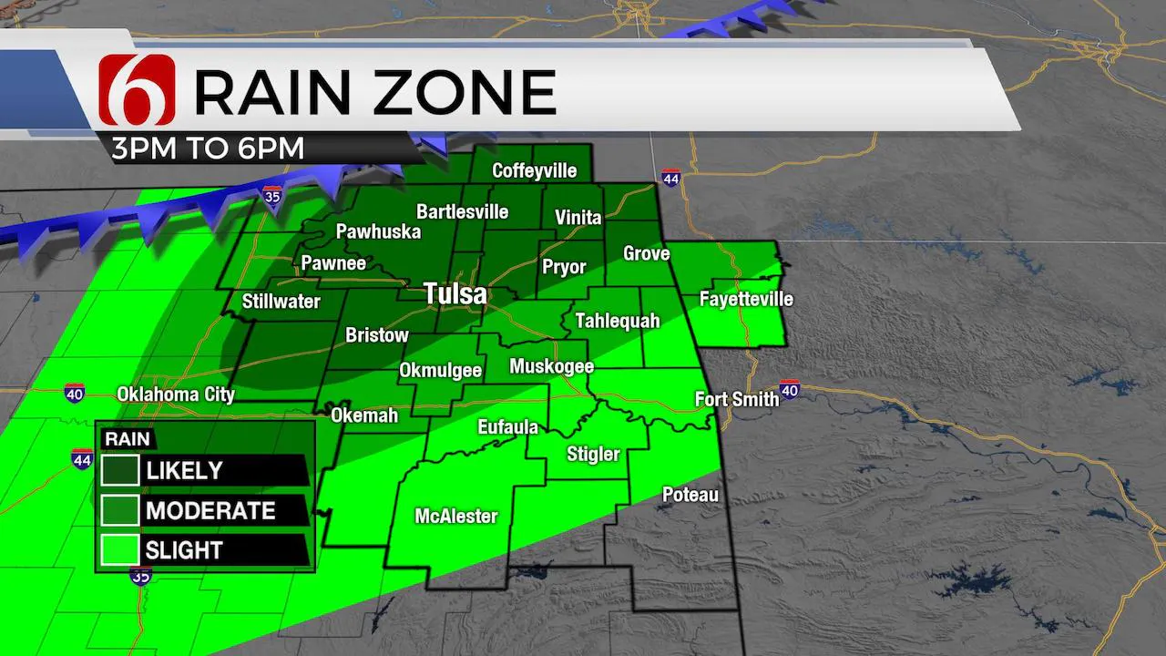
So far, the timing for this afternoon and evening event has been consistent. Strong mid to upper level winds from 80 to near 100 knots associated with the main upper level system diving down the northern to central plains will reach Kansas by midday. A surface area of low pressure will develop around midday along the boundary across south-central Kansas and will be moving east. A strong surface cold front will arrive across southeastern Kansas by 1pm and enter northern OK between 3pm and 4pm this afternoon. Storms will attempt to quickly developing along the advancing front and quickly become severe as the line drops southeast. The initial early hours of formation will support supercell development with all modes of severe weather possible. As time progresses, the wind parameters will support more of a linear or squall line formation with damaging winds and large hail the main threat.

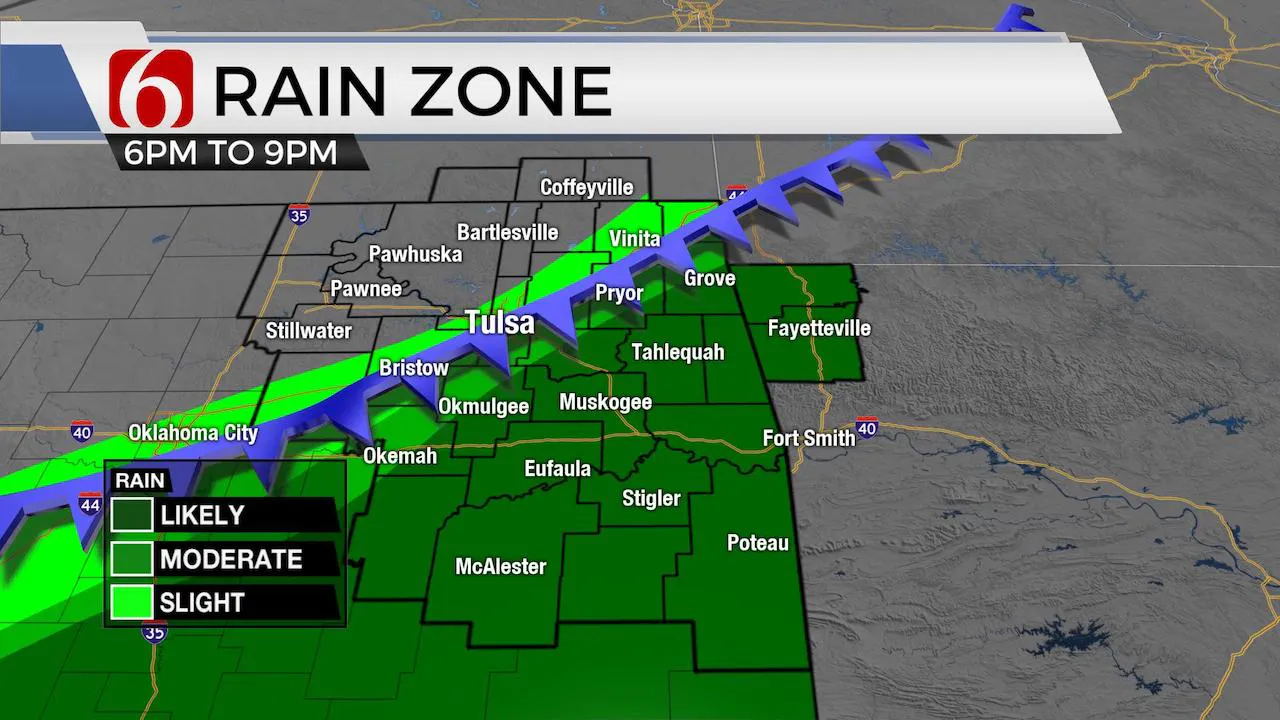
The metro window will be around 4pm to 6pm, with I-40 to McAlester to Muskogee to Tahlequah around 6pm to 8pm and exiting southeastern OK around 9pm to 10pm. As the front drops southward, forward speed of the line combined with very strong winds aloft will lead to straight line winds from 60 to 80 mph in spots, more so across the I-40 corridor into southeastern OK. Additionally, large hail nearing golf ball or slightly larger will be possible along with pockets of heavy rainfall will also be likely. The threats will quickly end with the frontal passage and improving weather will follow later tonight into Wednesday morning.
Wednesday highs will reach the lower 70s, Thursday into the upper 70s, Friday the mid-80s and Saturday near 90. Our next system arrives Sunday into early next week with stronger to severe storm chances.
Please remain aware of your weather surroundings today and this evening as this system nears your area.
Thanks for reading the Tuesday morning weather discussion and blog.
Have a super great day!
Alan Crone
More Like This
April 28th, 2020
December 12th, 2024
December 12th, 2024
December 12th, 2024
Top Headlines
December 12th, 2024
December 12th, 2024
December 12th, 2024
December 12th, 2024


