Thursday Highs In The Upper 60s
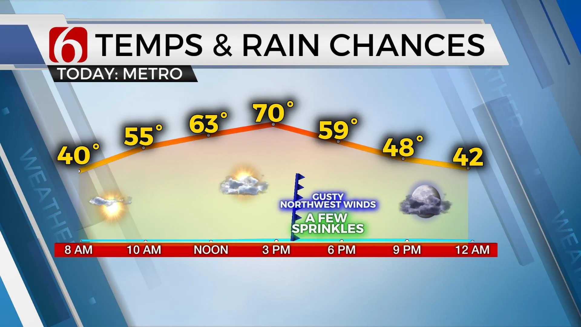
We’re tracking two more systems over the next few days, but the better chance for showers and storms will arrive Friday night into Saturday morning. We’re also watching Saturday evening along and east of Highway 69 for a few additional storms, including a few strong to severe. Today still looks good with highs in the upper 60s but we’ll also track a front arriving near the metro later this afternoon that will bring some changes into Eastern Oklahoma.Thursday, November 12th 2020, 5:09 am
We’re tracking two more systems over the next few days, but the better chance for showers and storms will arrive Friday night into Saturday morning. We’re also watching Saturday evening along and east of Highway 69 for a few additional storms, including a few strong to severe. Today still looks good with highs in the upper 60s but we’ll also track a front arriving near the metro later this afternoon that will bring some changes into Eastern Oklahoma.

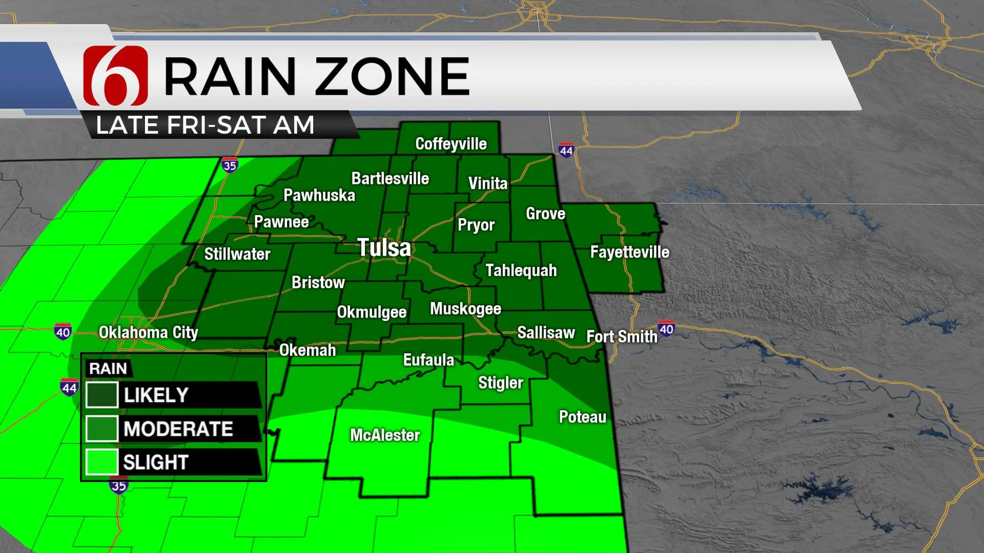
This weak cold front will move across the area later this afternoon around 4 p.m. before staling along the Red River Valley of southeastern OK and north TX late tonight. As this boundary shifts southward this evening, temps will drop along with gusty northwest winds for a few hours. There may be a few sprinkles near or south of I-40 for a short period. Highs Friday will remain in the 50s with mostly cloudy conditions. This same boundary will lift northward late Friday night into Saturday morning bringing showers and some thunder across northeastern OK before exiting by Saturday midday. The timing of it has changed some, but I’m not making any big changes at this point. We continue to keep most of Friday dry but will increase the rain chances by evening. Some data suggest the initial arrival of showers could be as early as Friday afternoon, but we’ll give the data another run before increasing the estimated time of arrival.
Strong low-level jet winds will roll across the region pre-dawn Saturday, but low-level moisture will remain rather meager and activity should remain below strong and severe levels for the early morning hours. As the low-level jet moves away from the area early Saturday morning, showers and storms will quickly end with south winds bringing highs in the lower 70s with partly sunny conditions Saturday afternoon. Another short-wave will zip across the central plains Saturday night into Sunday morning shoving another surface front southward into the state with a narrow line of showers or storms across extreme NE OK into SNW Arkansas late Saturday evening. The data is trending slightly higher with storm chances for Saturday evening near or east of the metro. The parameters would be increasing for a few strong to severe storms during this small window from Saturday 6 p.m. to around 1 a.m. Sunday and I’ve included a 30% for storms Saturday evening with this scenario. Sunday expect a return of north winds along with sunshine and afternoon highs in the 60s. We’ll remain in a holding pattern early next week with slowly warming temps before our next system nears.

The tropics remain active. Eta is making landfall across northwestern Florida this morning and will move across northeastern Florida later today as it weakens. Tropical storm Theta remains in the far eastern Atlantic Basin and will move eastward toward the African coast. Plus, we’re also watching a disturbance in the Eastern Caribbean that may blossom into another named tropical system over the next 5 to 7 days. Hurricane Season will officially end on November 31.
Thanks for reading the Thursday morning weather discussion and blog.
Have a super great day!
Alan Crone
KOTV
Be sure and check out my daily mini-podcast and weather briefing. Search for NewsOn6 and Weather Out The Door. You’ll find it on most podcast providers, including Apple, Tune-In Radio, Spotify, Stitcher and here on SoundCloud.
More Like This
November 12th, 2020
February 14th, 2022
January 26th, 2022
January 25th, 2022
Top Headlines
December 13th, 2024
December 13th, 2024
December 13th, 2024
December 13th, 2024


