

Severe Weather Chances Return To Green Country
Severe weather chances return to Green Country this week.Monday, April 11th 2022, 6:14 am
TULSA, Oklahoma -
Severe weather chances return to Green Country this week.
Here are the details from News On 6 Meteorologist Alan Crone:
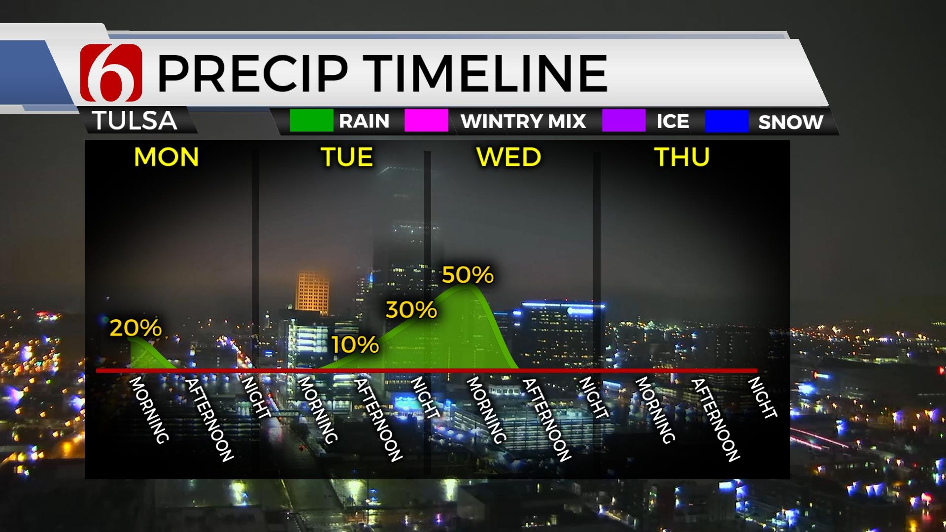
A complex weather scenario will be unfolding across the state during the next 60 hours presenting chances for severe thunderstorms. In addition to Monday morning's storm complex near and north, additional storm chances will remain Tuesday and Wednesday. The overall number of storms remains elusive at this point for Tuesday with the influence of a layer of warm air aloft, but the threat of severe weather must remain due to the expected parameters. As the system exits the area Wednesday midday to early afternoon, cooler weather is likely to arrive for the 2nd half of the week. It's possible to experience another frost or light freeze Thursday morning in extreme northeastern OK and northwestern Arkansas. Another system should be near the state by the weekend offering a chance for additional showers and possible thunder.

Lingering showers and storms will remain near and east of the area through the morning hours. Additional severe storms are likely to develop later this afternoon and early evening on the OK-AR state line region and quickly move into Arkansas. These storms will be severe, including all modes of severe weather. Most of this activity will remain east of our immediate areas this evening into Arkansas.

A weak front is located south of the metro this morning and should move slowly southward, stalling later this afternoon near the I-40 corridor before lifting northward overnight Tuesday morning. Low-level moisture is expected to rapidly move across the state into the central plains by Tuesday midday. A powerful upper-level system will bring strong winds aloft across the plains by afternoon and evening. A dry line is expected to develop across western OK and move eastward through the afternoon approaching eastern OK by early evening. A layer of warm air aloft (The CAP) may suppress thunderstorm activity along part but not all the dry line. Any storm or storms that can manage to form will be severe with very large hail, damaging winds, and heavy rainfall threats. Unfortunately, adequate wind shear will also be present allowing for a tornado threat, including the potential for a strong tornado. The actual chance for storms may not be exceptionally high in your immediate area. The CAP may hold suppressing any storms, but the chance for severe weather with any storm that can develop is high. The dry line will retreat westward overnight as the main upper trough begins pivoting closer to the state. A cold front will develop across Kansas and is expected to surge southeastward by Wednesday midday, overtaking the dryline and continuing east. Additional storms are likely to develop near and east of these features Wednesday morning and may also be severe with all modes of severe weather. As the front clears the state by midday, the severe weather threat will end. 
Wednesday night into Thursday morning cooler air arrives with overnight lows dropping into the 30s or lower 40s. A light frost or freeze is possible in a few valley locations. Thursday afternoon highs will reach the 60ss. This weekend morning lows will be in the 50s and highs will reach the lower 70s as another system nears with mentions for showers and storms.
Thanks for reading the Monday morning weather discussion and blog.
Have a super great day!
Alan Crone
KOTV
If you’re into podcasts, check out my daily weather update below. Search for NewsOn6 and ‘Weather Out The Door’ on most podcast providers, including Spotify, Stitcher, Tune-In and down below on Apple.


Get The Daily Update!
Be among the first to get breaking news, weather, and general news updates from News on 6 delivered right to your inbox!
More Like This
April 11th, 2022

June 21st, 2023

June 19th, 2023

June 13th, 2023
Top Headlines

December 11th, 2024

December 10th, 2024

December 10th, 2024

December 10th, 2024