

Weather Blog: Conditional Evening Storm Threats
Another warm and breezy day is ahead, but scattered storms are possible from late afternoon through the evening.Wednesday, April 20th 2022, 5:42 am
TULSA, Oklahoma -
Another warm and breezy day is ahead, but scattered storms are possible from late afternoon through the evening.
Here are the details from News On 6 Meteorologist Alan Crone:

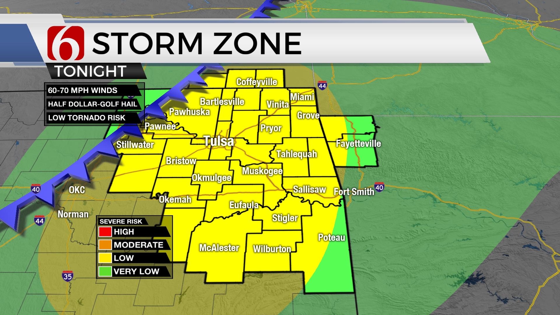
The first wave is moving east early Wednesday morning and taking scattered showers and storms out of the area quickly. Clouds will linger for the first half of the day before slowing exiting from the west to east by afternoon. This will create a broad range of temps today with upper 60s and lower 70s for eastern areas, nearing the upper 70s in the metro, and reaching the mid-80s to near 90 along the I-35 corridor. By the afternoon, a dry line will establish near central OK with a cold front moving across southeastern Kansas into far northern OK. If enough heating can occur ahead of these features, scattered storms will develop, including the threat of supercells with all modes of severe weather potential. While the actual number of any possible storm activity will not be high, any storms that can develop this afternoon and evening could be severe weather makers as they drop southeast for a few hours before weakening. This is a highly conditional threat. The capping inversion may prohibit storms from developing at all. This front is expected to sag southward near the highway 412 region, stall and then slowly move northward pre-dawn Thursday. A few additional storms could be possible along the north side of this boundary during this period with a low chance of severe storms pre-dawn Thursday.

Thursday and Friday feature strong south winds from 20 to 35 mph with mostly to partly cloudy sky and afternoon highs in the upper 70s and lower 80s. Forcing will be rather weak but nearby at times. There may be a few scattered showers or storms, but the overall probability remains low in our immediate areas of concern.

This weekend the main upper pattern transitions to a southwesterly flow bringing active weather into the plains, including Oklahoma. A few storms will be possible Saturday even though greater forcing will be north of the state. By late Saturday evening into Sunday morning, the main upper trough ejects slowly into the central plains while a surface boundary moves southeast. The upper air flow parallel to the boundary will provide for a slow-moving front with a prolonged period of rain and storms Sunday. The severe threats will be present but should remain somewhat low. The heavy rainfall could support some flooding across far eastern OK and western Arkansas, including along the Illinois River Basin. This front finally clears the area Sunday evening bringing a cooler Monday.
Thanks for reading the Thursday morning weather discussion and blog.
Have a super great day!
Alan Crone
KOTV
If you’re into podcasts, check out my daily weather update. Search for NewsOn6 and ‘Weather Out The Door’ on most podcast providers, including Spotify, Stitcher and Tune-In, or Click Here to listen on Apple Podcasts.

Get The Daily Update!
Be among the first to get breaking news, weather, and general news updates from News on 6 delivered right to your inbox!
More Like This
April 20th, 2022

June 21st, 2023

June 19th, 2023

June 13th, 2023
Top Headlines

December 13th, 2024

December 13th, 2024

December 13th, 2024

December 13th, 2024