

Tracking A Break From The Heat Soon
Expect more summer heat on Wednesday before storm chances return to Green Country.Wednesday, July 27th 2022, 6:23 am
TULSA, Oklahoma -
Expect more summer heat on Wednesday before storm chances return to Green Country.
Here are the details from News On 6 Meteorologist Alan Crone:

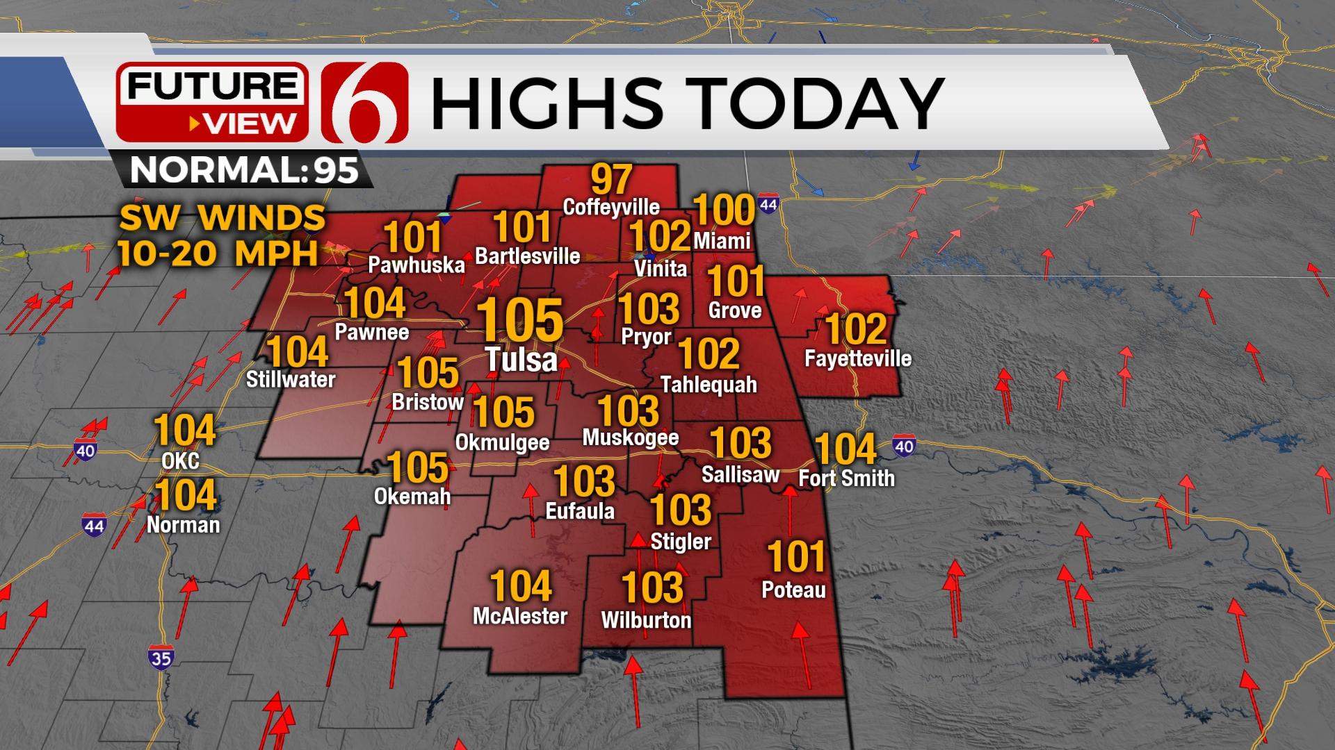
Another hot afternoon is likely today before a boundary brings increasing rain chances and a reduction in afternoon highs across northern Oklahoma for the end of the week. Precipitation probabilities remain through the weekend, with higher likelihoods located across the northern third of the region. This should bring below normal temperatures Friday through the weekend before hot weather returns next week.

A few showers are possible this morning along the OK-KS state line region as the much-advertised boundary slowly moves south. A few additional pop-up storms will be possible later this afternoon with daytime heating bringing highs from 100 to 106. Another heat warning and advisory will be required today with afternoon heat index values from 105 to 113. Thursday, the front finally drops southward bringing a few scattered storms and highs dropping into the mid-90s north, while southeastern OK remains in the triple digits. The front should stall across southern OK Thursday evening as additional showers and storms develop along and north of the boundary. This zone should correspond to the area along and north of highway 412, where some locally heavy rainfall will be possible in a few localized regions where training of cells will be possible. This same area may also experience another flare-up of storms late Friday evening into Saturday morning with the boundary remaining mostly stationary to our south. It’s this period that offers the best reduction in temperature with morning lows in the upper 60s and lower 70s with afternoon highs in the lower 80s Saturday afternoon. The boundary will become diffuse by Saturday afternoon with south winds returning into Sunday as scattered showers and storms become less numerous. Highs Sunday will reach near 90 before moving back into the triple digits by Tuesday and Wednesday of next week.
Thanks for reading the Wednesday morning weather discussion and blog.
Have a super great day!
Alan Crone
KOTV
If you’re into podcasts, check out my daily weather update. Search for NewsOn6 and ‘Weather Out The Door’ on most podcast providers, including Spotify, Stitcher and Tune-In, or Click Here to listen on Apple Podcasts.

Get The Daily Update!
Be among the first to get breaking news, weather, and general news updates from News on 6 delivered right to your inbox!
More Like This
July 27th, 2022

June 21st, 2023

June 19th, 2023

June 13th, 2023
Top Headlines

December 13th, 2024

December 13th, 2024

December 13th, 2024

December 13th, 2024