

Record Highs Before A Cold Front Arrives
Another day of warm temperatures is expected, but a couple of cold fronts could soon bring some relief.Wednesday, September 21st 2022, 6:46 am
TULSA, Okla. -
Another day of warm temperatures is expected, but a couple of cold fronts could soon bring some relief.
Here are the details from News On 6 Meteorologist Alan Crone:

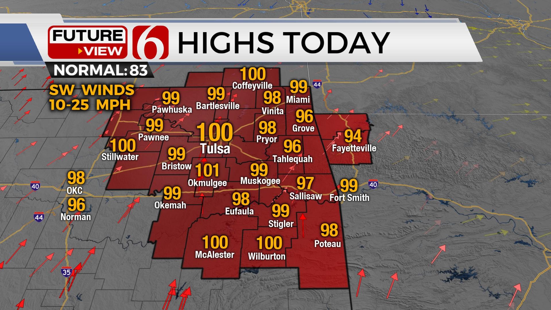
Record highs are expected across the area on Wednesday with afternoon temperatures reaching triple digits near and west of the Tulsa metro. The good news: we're tracking two cold fronts. The first arriving Thursday morning brings some relief for the northern third of the state. Hot weather returns Friday into Saturday before our next front ushers in seasonal weather early next week.

The strong midlevel ridge of high pressure flattens slightly overnight into early Thursday morning as a short-wave trough scoot across the northern plains into the Midwest. This opens the gate for a southward moving cold front bringing some temporary relief from the heat, at least across northeastern Oklahoma Thursday. Southern sections, along and south of I-40, will cool-down compared to Wednesday, but will still reach the lower 90s Thursday afternoon. Northeastern Oklahoma will experience gusty northeast winds and highs in the 70s. This will be a pleasant respite from the triple digit temps were expecting today. Any shower activity with the late Wednesday evening and Thursday morning system should remain slightly north. Even if we manage to somehow catch a shower or two, measurable precip is not likely. Unfortunately, south winds return Friday as the ridge expands north and brings more hot weather. We'll reach the lower 90s Friday and the mid to upper 90s Saturday before a stronger front moves across the state late Saturday evening and Sunday morning. The main benefit from this front will be felt early next week as drier low-level air moves into the state as a surface ridge of high-pressure centers near the area. This will bring morning lows in the 50s, with some upper 40s Monday and Tuesday morning in a few valley locations. Afternoon highs will reach the lower 80s to mid-80s early next week.

We continue to monitor several disturbances in the Atlantic Tropical basin, including a system that may threaten the U.S. next week. For more on this, please listen to my daily podcast, " Weather Out the Door". You'll find the link at the bottom of this forecast discussion.
Thanks for reading the Wednesday morning weather discussion and blog.
Have a super great day!
Alan Crone
KOTV
Check out my daily weather update. Search for NewsOn6 and ‘Weather Out The Door’ on most podcast providers, including Spotify, Stitcher and Tune-In, or Click Here to listen on Apple Podcasts.

Get The Daily Update!
Be among the first to get breaking news, weather, and general news updates from News on 6 delivered right to your inbox!
More Like This
September 21st, 2022

June 21st, 2023

June 19th, 2023

June 13th, 2023
Top Headlines

December 13th, 2024

December 13th, 2024

December 13th, 2024

December 13th, 2024