

Colder Weather Arriving Soon
A warm and windy Wednesday is ahead, but storm chances could soon return as the week nears an end.Wednesday, November 9th 2022, 6:34 am
TULSA, Okla. -
If you’re into podcasts or in a rush, check out my daily weather update. Search for NewsOn6 and ‘Weather Out The Door’ on most podcast providers, including Spotify, Stitcher and Tune-In, or Click Here to listen on Apple Podcasts.
TULSA Okla. - A warm and windy Wednesday is ahead, but storm chances could soon return as the week nears an end.
Here are the details from News On 6 Meteorologist Alan Crone:

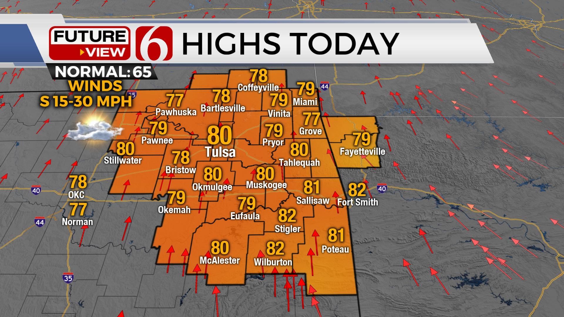
Some pockets of drizzle and fog will be possible in a few locations on Wednesday morning, despite a quickly developing south wind. Highs on Wednesday afternoon will reach the upper 70s and lower 80s, nearing record highs in some locations before a strong cold front brings much colder weather for the end of the week into the weekend. The pattern continues to support colder weather for most of next week as at least two additional systems may brush the state.

Low-level moisture continues streaming into the state with a few spots under dense fog advisories for the early morning hours. We’ll see some patchy fog or a few areas of mist, but widespread issues are not expected across northeastern Oklahoma on Wednesday morning. Low-level clouds will continue through at least midday before thinning from the west to east. The clearing may occur faster across the western half of the state allowing even stronger afternoon winds from 20 to 40 mph west of I-35. Our wind speeds across the eastern third should remain from 15 to 30 mph.

A powerful upper-level system will eject from the western U.S. into the central plains Thursday afternoon and evening. This will bring a strong cold front across the area Thursday afternoon and evening with thunderstorm chances. A few of the storms may become strong to severe, but the stronger lift with this system should stay slightly north of the state line, mostly across eastern Kansas and northward into the Midwest where higher chances for severe weather will occur. This same strong upper trough will bring a big winter storm across the northern plains Thursday.

As the front slides southeast Thursday evening, some data support mostly post-frontal showers and storms for northeastern OK. This should limit the overall severe threats, but a good portion of the region will experience some measurable rainfall. The initial surge of colder air is mostly pacific, but a Canadian surface ridge is expected to develop southward bringing colder weather into the state Friday through the weekend. This system also signals the return of below-seasonal temperatures which should remain for most of the next week. There will also be at least two additional storm systems that may influence our weather next week. While it’s too early to know any specifics at this point, the potential for a strong upper-level system nearing our area Monday into Tuesday brings the potential for some wintry weather impacts. More on this tomorrow.

Thanks for reading the Wednesday morning weather discussion and blog.
Have a super great day!
Alan Crone
KOTV

Get The Daily Update!
Be among the first to get breaking news, weather, and general news updates from News on 6 delivered right to your inbox!
More Like This
November 9th, 2022

June 21st, 2023

June 19th, 2023

June 13th, 2023
Top Headlines

December 13th, 2024

December 13th, 2024

December 13th, 2024

December 13th, 2024