

Tracking A Strong Storm System Soon
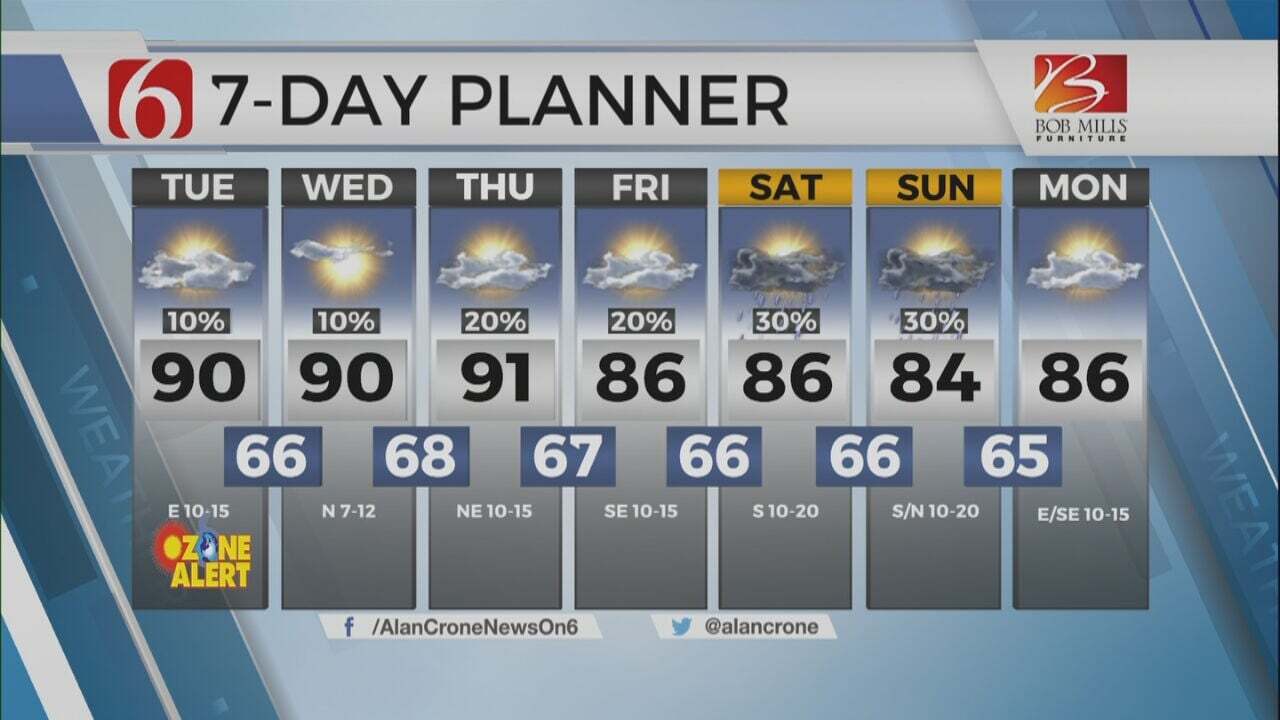
More warm temperatures are expected across Green Country on Wednesday before another storm system brings severe weather threats back to the state.Wednesday, March 1st 2023, 6:03 am
If you’re into podcasts or in a rush, check out my daily weather update. Search for NewsOn6 and ‘Weather Out The Door’ on most podcast providers, including Spotify, Stitcher and Tune-In, or Click Here to listen on Apple Podcasts.
TULSA, Okla. - More warm temperatures are expected across Green Country on Wednesday before another storm system brings severe weather threats back to the state.
Here are the details from News On 6 Meteorologist Alan Crone:

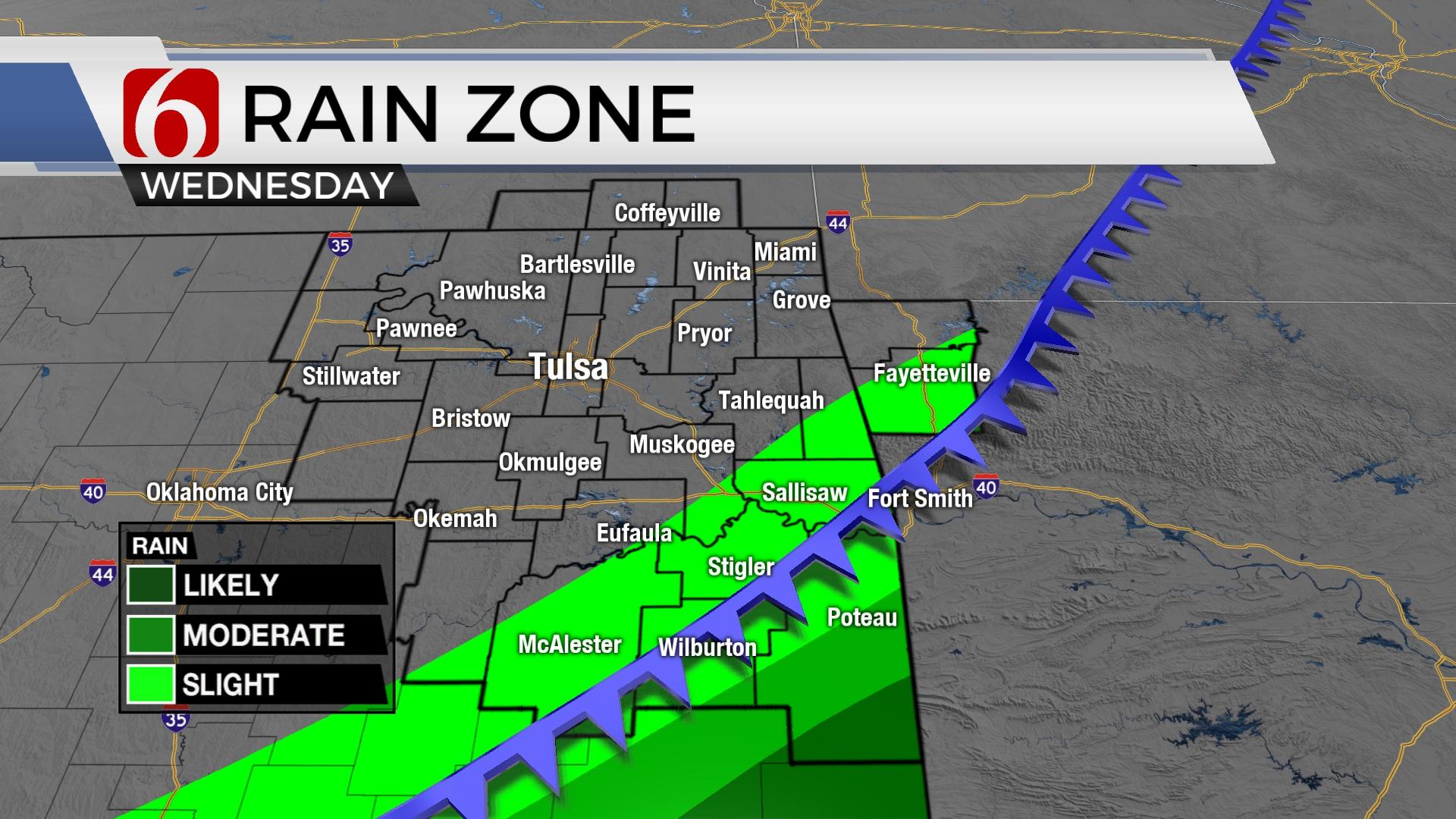
A weak front crosses the area on Wednesday morning bringing gusty north winds during the early morning hours and highs cooler than the previous few days with most locations reaching the mid-60s. A few isolated storms are possible across extreme southeastern Oklahoma today and tonight where lower 70s will remain. But a powerful storm system brings threats for strong and severe storms back into the portions of the state Thursday, including the potential for all modes of severe weather.

The warm sector of the developing system continues to be a complicating factor regarding the exact location of the northern extent of severe weather potential. The current severe weather risk assessment encompasses a large area of southcentral to eastern OK, with more significant threats along and south of I-40. This is mostly the same areas depicted yesterday, but the far northern edge of this threat does include the I-44 corridor from OKC to the Tulsa region for strong to severe storms. Additionally, some locally heavy rainfall threats will be possible Thursday evening into early Friday.

The powerful upper-level trough will begin influencing the area on Wednesday with a lead wave ejecting across north Texas into southwestern Arkansas. A surface cold front has already moved south of the metro and will encounter southeastern OK midday to afternoon where a few isolated cells will be possible. Locations slightly more south, along a line from Sherman to Bonham to Hugo to Broken Bow will be in a slightly better position to experience a few storms this afternoon and early evening that could be severe. The boundary in this general region will begin lifting northwest as a warm front early Thursday as the main upper trough enters New Mexico. A broad surface area of low pressure will develop across the high plains of Texas as pressure falls and will direct southeast winds flowing into the region from north TX and southern OK as the boundary lifts northwest. Daytime highs will reach the 70s along and south of the front with locations north of the boundary remaining in the 50s to lower 60s. The position of the quasi-warm frontal boundary will be a key to more significant severe weather including the potential for supercell storms.

Early Thursday morning, a few scattered showers and storms will begin developing near and north of the boundary. These will be elevated and may produce some small hail and gusty winds in stronger cores as a few storms move northeast across the area. By midday, additional storms will begin developing as the powerful upper-level trough draws closer to the state. All modes of severe weather will remain possible. Several scenarios will be possible including some warm sector discrete supercells initially before a linear system develops along the westward advancing pacific boundary.

As the trough pivots along the Red River, a surface low is expected lift east to northeast bringing north winds and colder air across southeastern Kansas into far northern OK as strong to severe storms remain in the warm sector across the southeastern quadrant of the state. The threat for severe weather will move out of the area Thursday evening while locations along and northwest of I-44 will see wrap around rain attempting to mix with some snow. The duration of the back-side moisture does not seem long enough to overlap with the coldest column of air and no significant wintry weather is expected. But some differences in the data remain with some scenarios suggesting minor accumulations on grassy areas. The precipitation quickly ends early Friday while blustery north winds from 30 to 45 mph remain early Friday morning with wind chills from the teens into the mid-20s. Wind speeds should decrease after the early morning to midday hours. Surface temps in the mid-30s early Friday will reach the lower 50s by afternoon with decreasing clouds. Most of the weekend appears pleasant with Saturday afternoon highs in the mid to upper 50s, and Sunday into the 60s, before reaching the 70s early next week. Another surface cold front nears by the middle of next week with another cool-down Tuesday through the end of the week.

Thanks for reading the Wednesday morning weather discussion and blog.
Have a super great day!
Alan Crone
KOTV

Get The Daily Update!
Be among the first to get breaking news, weather, and general news updates from News on 6 delivered right to your inbox!
More Like This
March 1st, 2023

July 3rd, 2023

June 8th, 2023
June 6th, 2023
Top Headlines

December 12th, 2024

December 12th, 2024

December 12th, 2024

December 12th, 2024