Pop-Up Storm Chances Remain
Another warm summer day is ahead, but parts of Green County could see a few pop-up storms.Tuesday, June 6th 2023, 5:14 am
If you’re into podcasts or in a rush, check out my daily weather update. Search for NewsOn6 and ‘Weather Out The Door’ on most podcast providers, including Spotify, Stitcher and Tune-In, or Click Here to listen on Apple Podcasts.
TULSA, Okla. - Another warm summer day is ahead, but parts of Green County could see a few pop-up storms.
Here are the details from News On 6 Meteorologist Alan Crone:
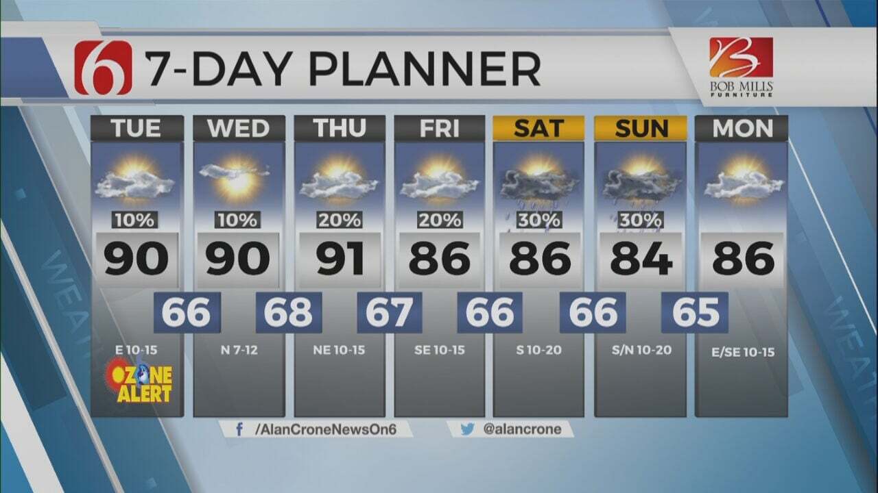
A continuation of afternoon and early evening pop-up thunderstorm chances will remain on Tuesday and Wednesday before a pattern change brings a chance for more organized thunderstorm chances Friday through the weekend. The upper air pattern will also change this weekend into early next week allowing a much stronger upper flow across the southern plains. Pattern recognition would support the possibility of severe weather due to the stronger flow early next week, yet the overall details in the mesoscale synoptics will determine probabilities for the period of Monday through Wednesday of next week. Afternoon highs on Tuesday will reach the upper 80s and lower 90s with sunshine followed by partly cloudy conditions through the afternoon. A relatively light breeze, mostly from the east at 5 to 12 mph combined with typical early June moisture values support the formation of ozone on Tuesday. Therefore, an ozone alert will be issued for the Tulsa metropolitan region on Tuesday.
Here’s more information regarding the Ozone Alert from the National Weather Service.
An ozone alert means that conditions are favorable for the buildup of ozone near the ground, to an unhealthy level.
When winds are light, the vapors from fuels such as gasoline, exhaust from engines, and air pollutants from industrial activities remain trapped near the ground. If sunshine is abundant when these air pollutants build up, a chemical process is triggered that results in the development of ozone near the ground during the afternoon and evening hours.
While ozone in the upper levels of the atmosphere is beneficial in screening the suns radiation, it is harmful near the ground. Ozone can bother those with respiratory problems and can damage vegetation.
Similar conditions are also expected on Wednesday with little change in the atmosphere.
By Thursday, the main upper-level ridge across central U.S. is weakening. The weak Omega block is breaking down. A broad upper-level low across the Midwest and Great Lakes will help to push a surface boundary through the Missouri Valley into far northeastern OK before stalling. The upper air flow from the northwest combined with this front will give a slightly better chance for a few organized storms across the eastern third of the state before this front becomes diffuse. The upper flow will also bring a few disturbances near the state Friday through the weekend also featuring the potential for a small complex of storms nearing Friday evening into early Saturday and again Saturday night into early Sunday morning. Another weak back-door front is scheduled to arrive Sunday from the Missouri Valley. This one may survive longer providing northeast winds and a minor reduction in afternoon highs on Sunday.
The main period of interest continues to be early next week when a very strong subtropical jet arrives around the base of an ejecting western U.S. trough. This flow is more common in May. Combined with June moisture and heat, the potential for strong and severe storms will be monitored closely during this period. We’ll have more information regarding early next week tomorrow.
Thanks for reading the Tuesday morning weather discussion and blog.
Have a super great day!
Alan Crone
KOTV

Get The Daily Update!
Be among the first to get breaking news, weather, and general news updates from News on 6 delivered right to your inbox!
More Like This
June 6th, 2023

July 3rd, 2023

June 8th, 2023

June 5th, 2023
Top Headlines

April 26th, 2024

April 26th, 2024

April 26th, 2024

April 26th, 2024
