

Pop-Up Storms Remain Before Increasing Weekend Chances
Warm temperatures stick around on Monday, but parts of Green Country could see some showers.Monday, June 5th 2023, 5:27 am


If you’re into podcasts or in a rush, check out my daily weather update. Search for NewsOn6 and ‘Weather Out The Door’ on most podcast providers, including Spotify, Stitcher and Tune-In, or Click Here to listen on Apple Podcasts.
TULSA, Okla. - Warm temperatures stick around on Monday, but parts of Green Country could see some showers.
Here are the details from News On 6 Meteorologist Alan Crone:
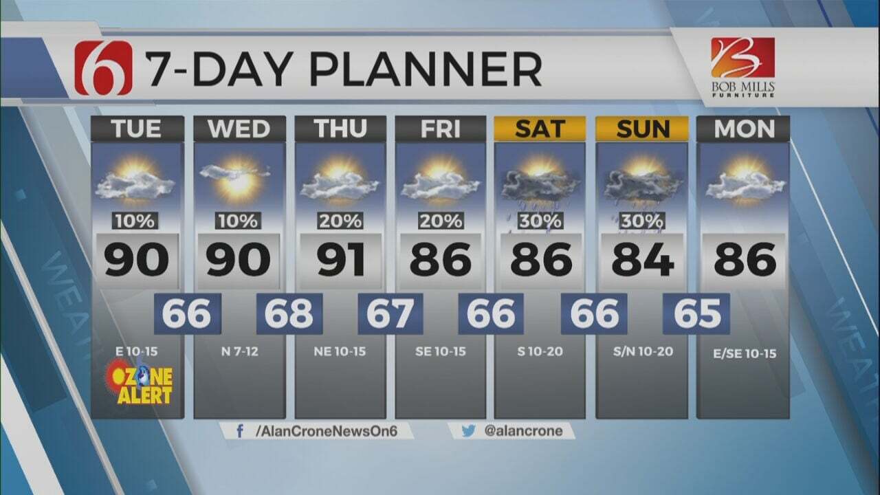
A few pop-up storms will remain possible for the next few days, including on Monday. Afternoon highs will be slightly above seasonal averages throughout the week. The weak upper air flow will keep major systems out of the area in the short term. Most storms will remain below severe levels, but a few may pulse up producing downburst winds, small hail, frequent lightning and very heavy rainfall in highly localized areas.
The upper air pattern is characterized by a mid-level ridge across the north-central U.S. with a broad upper low across the northeastern sections of the country. Another strong low is positioned across the southwestern U.S., near the Baja region. This pattern resembles a weak Omega block keeping major systems away from the middle of the nation. But local influences of seasonal low-level moisture with daytime heating combined with some weak upper-level flow will continue to result in daily, low-end shower and storm chances through the next few days. The pattern will change by the end of the week as the mid-level ridge weakens and the broad troughing across the northeast attempts to allow a back-door boundary to near the state Thursday or Friday. Data has been flirting with this front moving across the area for the past few model runs. This would be highly unusual for this time of year for this boundary to remain intact and have any major impact for our immediate area. This front should arrive Friday across the far eastern sections of the state but should stall, become diffuse, and wash-out as the southwestern upper low is allowed to eject into the desert southwest by the end of the week. This will bring stronger upper-level flow from the west to southwest across the state this weekend into next week. The positioning of the stronger flow in most data suggests more organized thunderstorm chances should return this weekend and continue early next week. Additional data on Monday morning also suggests another back-door boundary will be near the state Sunday. The upper air flow will be slightly stronger during this period and could keep this front intact across part of the area Sunday. We're still watching for any major signal for a bout of northwest flow mesoscale convective systems impacting the region, which is typical for early to mid-June. Data early next week also features a much stronger upper air flow across the southern plains that could bring threats of severe weather to the region.
Thanks for reading the Monday morning weather discussion and blog.
Have a super great day!
Alan Crone
KOTV

Get The Daily Update!
Be among the first to get breaking news, weather, and general news updates from News on 6 delivered right to your inbox!
More Like This

June 5th, 2023

July 3rd, 2023

June 8th, 2023
June 6th, 2023
Top Headlines

December 13th, 2024

December 13th, 2024

December 13th, 2024

December 13th, 2024