

Springlike Thunderstorms Return For The Weekend
Warm weather sticks around on Thursday, but shower and storm chances are on the horizon.Thursday, June 8th 2023, 5:39 am


If you’re into podcasts or in a rush, check out my daily weather update. Search for NewsOn6 and ‘Weather Out The Door’ on most podcast providers, including Spotify, Stitcher and Tune-In, or Click Here to listen on Apple Podcasts.
TULSA, Okla. - Warm weather sticks around on Thursday, but shower and storm chances are on the horizon.
Here are the details from News On 6 Meteorologist Alan Crone:
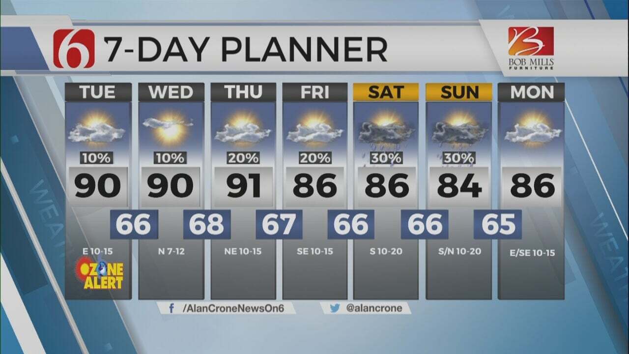
Temperatures will climb into the upper 80s and lower 90s ahead of a back door boundary arriving from the Southwestern Missouri area later Thursday afternoon. This front will either become diffuse or stall across the far eastern regions of the state. A few scattered showers and storms will be likely near this boundary, mostly across extreme northeastern Oklahoma and northwestern Arkansas. Similar conditions are expected on Friday, but the boundary may slip into far northern Oklahoma through part of the day. Temperatures on Friday morning will start in the upper 60s, with daytime highs returning into the upper 80s or even lower 90s. Wind direction on both Thursday and Friday will be variable with speeds mostly light from 7 to near 15 mph. A few additional scattered showers and storms will remain possible Friday, but the coverage should also remain sparse for many locations. The upper air pattern undergoes a change into the weekend, allowing higher chances for showers and storms, including the potential for a few storm clusters or complexes to impact part of the area.

Stronger upper air flow arrives across northwestern Oklahoma Friday and will trigger scattered showers and thunderstorms in those areas by afternoon. Friday night into early Saturday morning, a complex of storms will drop eastward and could impact our area early Saturday morning. The leading edge of the storm complex could be still strong near severe but should be weakening through the early morning hours. A dry line will be established across far western Oklahoma Saturday afternoon. Additional storms will develop along this feature and form another complex of storms dropping east or southeast Saturday night into early Sunday morning. The eventual outcome of this complex depends on what happens early Saturday morning with thunderstorms across eastern Oklahoma. Regardless, thunderstorm chances will continue through part of the weekend, including early Saturday morning, and then again late Saturday night into early Sunday morning. The upper pattern will allow a surface boundary to move through the entire state Sunday, bringing north winds and highs into the lower 80s north and mid-80s. Monday appears pleasant, with morning lows in the 60s and daytime highs in the lower 80s. But Monday night into Tuesday, a much stronger upper airflow moves across the central and southern Plains. The Sunday cold front will return as a warm front Tuesday, with thunderstorm chances increasing across the state. The presence of the boundary, increasing low-level moisture, temperatures moving into the mid-80s, and a very strong upper air flow will support the mention of severe weather. There remain differences in the outcome of the surface boundary for Tuesday and Wednesday. We’ll need to keep thunderstorm chances for both Tuesday and Wednesday until the data becomes more consistent. As this system moves east of the state Wednesday, toasty weather quickly arrives, with highs reaching at least the lower to mid-90s for the middle of next week.
Thanks for reading the Thursday morning weather discussion and blog.
Have a super great day!
Alan Crone
KOTV

Get The Daily Update!
Be among the first to get breaking news, weather, and general news updates from News on 6 delivered right to your inbox!
More Like This

June 8th, 2023

July 3rd, 2023
June 6th, 2023

June 5th, 2023
Top Headlines

December 12th, 2024
December 12th, 2024

December 12th, 2024

December 12th, 2024