

Another Round Of Scattered Showers & Storms
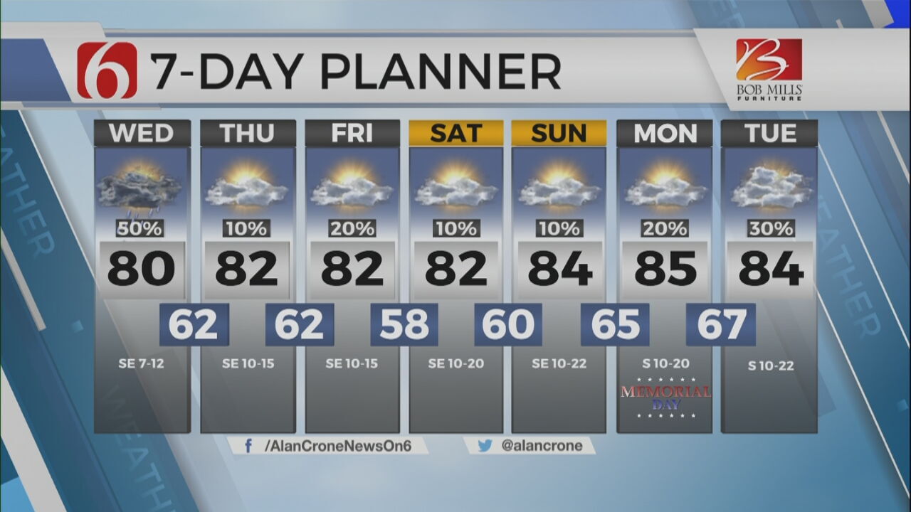
The chance for scattered showers and storms sticks around for parts of Green Country on Wednesday.Wednesday, May 24th 2023, 5:59 am
If you’re into podcasts or in a rush, check out my daily weather update. Search for NewsOn6 and ‘Weather Out The Door’ on most podcast providers, including Spotify, Stitcher and Tune-In, or Click Here to listen on Apple Podcasts.
TULSA, Okla. - The chance for scattered showers and storms sticks around for parts of Green Country on Wednesday.
Here are the details from News On 6 Meteorologist Alan Crone:
The coverage of scattered showers and storms will be greater on Wednesday compared to Tuesday, but some locations will remain dry. Highs on Wednesday afternoon will reach the upper 70s or lower 80s with mostly cloudy sky and southeast winds near 10 mph. The upper air flow remains weak across eastern OK. This means organized severe weather is unlikely. A few stronger cores this afternoon may produce some highly localized downbursts of heavy rain and gusty winds. Some small hail will be possible with the stronger cores. A few showers will remain possible Thursday but with a much lower coverage across eastern Oklahoma compared to today. The extended Memorial Holiday Weekend forecast remains much the same with morning lows in the upper 50s to lower 60s and afternoon highs in the lower 80s Sunday and Monday. The upper air flow remains favorable for bringing storm systems nearby. But, at this point, we continue with only low-end chances for the weekend. The pattern bears the possibility of some higher chances than currently advertised, but we’ll continue with relatively low chances for the forecast.
The main upper air flow remains mostly weak with the stronger flow well north of the state. A mid-level ridge of high pressure will extend near and northeast of the state early this weekend. A surface ridge of high pressure will be positioned across the Great Lakes with a surface low across the southeastern U.S. and another surface low well west of the state. We’ve remained consistent with our low-end chances for showers and storms this weekend into early next week. Some changes in the forecast will remain possible. We encourage you to check often as we move into early next week.
Highs on Wednesday will reach the upper 70s and lower 80s. Southeast winds remain for most of the day in the 7 to 15 mph range.
Thanks for reading the Wednesday morning weather discussion and blog.
Have a super great day!
Alan Crone
KOTV

Get The Daily Update!
Be among the first to get breaking news, weather, and general news updates from News on 6 delivered right to your inbox!
More Like This
May 24th, 2023

July 3rd, 2023

June 8th, 2023
June 6th, 2023
Top Headlines

December 15th, 2024

December 14th, 2024

December 14th, 2024

December 14th, 2024