More Fine Fall Weather.
<p>Another beautiful day expected for Friday and more nice weather through the weekend.</p>Thursday, September 29th 2016, 9:41 pm
Quick update this evening, just returned from duty at the Tulsa State Fair; met lots of nice folks and the weather could not be better. Speaking of which, if you liked today you will certainly like Friday as very little change is expected. Clear skies and light winds tonight together with dry air in place will lead to another cool start to our day with mornings lows in the 40s to near 50. Sunny skies but light northerly winds for much of the day Friday will keep our afternoon temperatures in the mid 70 so another beautiful day.
Conditions will be slowly changing over the course of the weekend with our winds returning to a more S/SE direction for Saturday and Sunday, but moisture will be slow to return. So, except for some high level cirrus clouds, we should still have lots of sunshine both days and somewhat milder temperatures. In fact, our morning lows will be back into the 50s and daytime highs closer to the 80 degree mark which is back above normal for this time of year. As a reminder, the normal max/min is 78/59 and today we recorded 76/50.
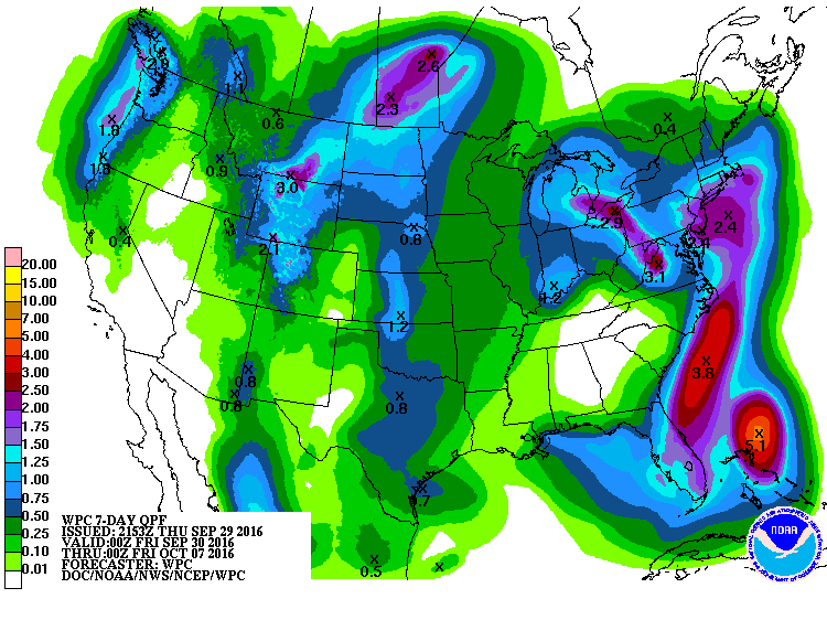
Going into next week, look for temperatures to be even warmer, particularly at night due to southerly winds eventually bringing more moisture our way. That means more cloud cover and eventually a chance of rain. But, as you can see on our forecast page, the chances are still not all that great and right now appear to be centered on the middle part of the week. A system aloft will be passing through the state bringing the rain chances and perhaps even some storms. But, as you can see on the 7 day QPF, the potential for any significant rainfall is not very impressive and as mentioned yesterday, that will likely change again over the next few data runs until we get a better handle on the next system.
[img]
At any rate, it still looks like mighty nice fall weather going through the weekend followed by the warming trend for the early part of the week and then another cool-down for the latter part of the week. But, this does not appear to be a particularly strong system so the cooling is not expected to be too dramatic.
In fact, the 8-14 day outlook brings temperatures back above normal in time for the following weekend. Again, that would most likely translate to daytime highs back into the 80s and overnight lows well into the 50s or 60s. Also, the 8-14 day outlook is now keeping our chances of additional moisture in the slim to none category.
[img]
[img]
So, stay tuned and check back for updates.
Dick Faurot
More Like This
September 29th, 2016
September 29th, 2024
September 17th, 2024
Top Headlines
December 13th, 2024
December 13th, 2024
December 13th, 2024
December 13th, 2024


