

Spring-Like Weather For Green Country This Weekend
Pleasant weather is likely for most of the area today, but we’re starting with patchy and dense fog in some locations this morning. Any fog should quickly subside after the 9am as gusty south winds return, and temperatures begin to climb.Friday, March 26th 2021, 7:00 am
TULSA, Oklahoma -
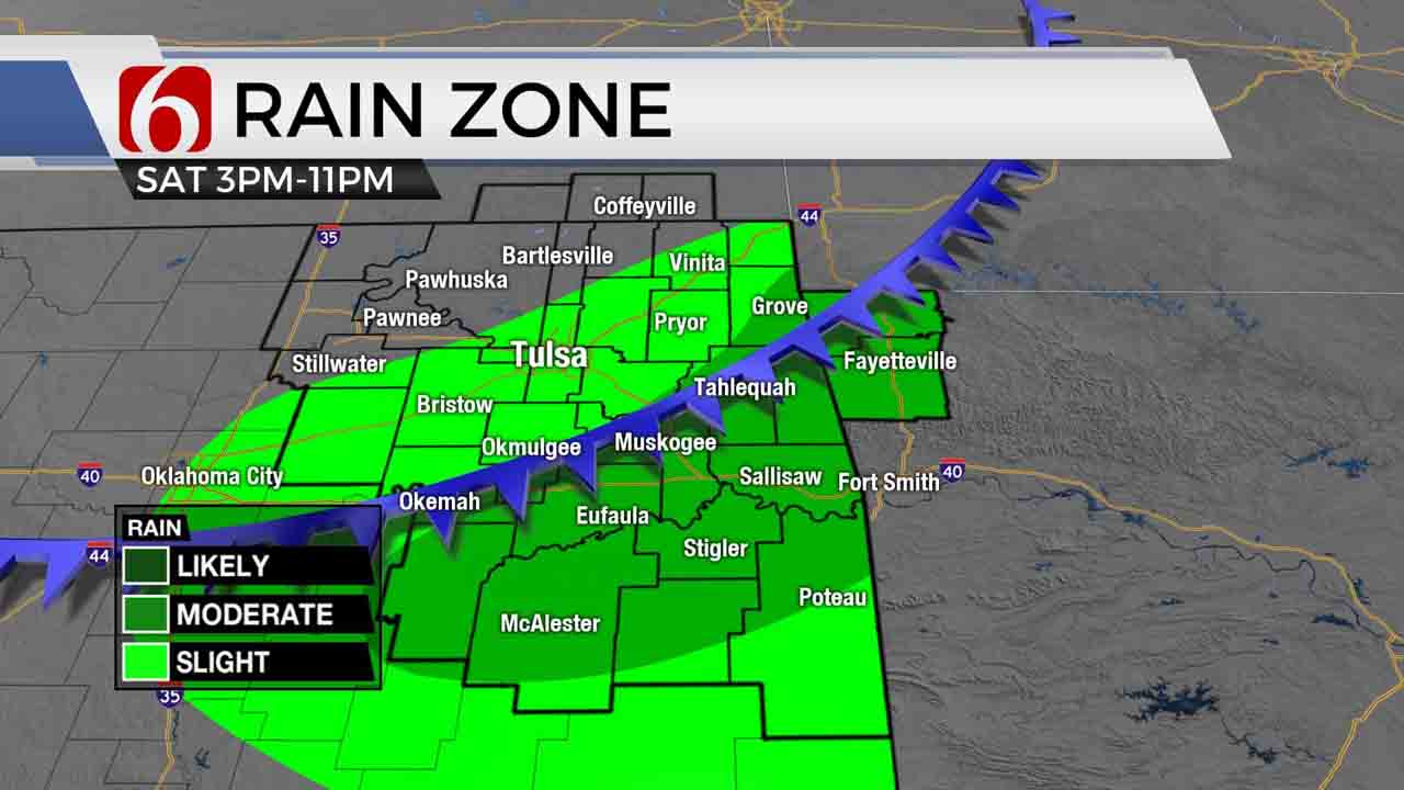
Pleasant weather is likely for most of the area today, but we’re starting with patchy and dense fog in some locations this morning. Any fog should quickly subside after the 9 a.m. as gusty south winds return, and temperatures begin to climb. We’ll be approaching highs in the lower to mid-70s near the metro with slightly higher readings across southeastern OK. Despite the recent rainfall, the fire danger spread rates will increase this afternoon. If a fire starts, it will spread quickly. We’re also looking at a decent weekend, but as I’ve been discussing for the past few days, there will remain a chance for a few storms Saturday as a cold front approaches from the north tomorrow afternoon. If storms do develop, a few could be strong to severe, but the overall chance for storms will remain mostly southeast of the metro. Locations across far east-central to southeastern OK will have a slightly better chance for a few storms tomorrow evening. The front will bring very pleasant weather Sunday for the region with north winds and drier air for the afternoon. Highs will reach the upper 60s and lower 70s. We also continue to have some discrepancies regarding the pattern for early next week, including the potential for storms Monday, but the consensus is higher now for a few storms Tuesday night into Wednesday morning as another cold front approaches the area.

A weak disturbance will eject across the central plains tonight and scattered storms are likely to develop along the I-70 corridor, well north of the OK-KS state line region. But a surface front in this region will move southward tonight and should be entering northern OK around noon to 3pm Saturday. The forcing will remain limited and mostly due to the approach of the surface boundary before stronger upper-level forcing arrives later Saturday night from the west. The impact could bring a few storms near the area Saturday, mostly southeast of the metro, during the late afternoon and evening hours. As the trough nears and the front drops south, additional storms are likely to develop and move quickly into Arkansas, where severe storms will be more likely.

Sunday we’re on the back side of the system and most of the day looks great with a surface ridge of high pressure the dominant feature. Monday morning through midday, the EURO has been hinting with a disturbance nearing the state, while the GFS counterpoint has been mostly void of this feature. We’ve been flipping back and forth with a small pop for Monday, but this morning both sets of data seem to suggest our main forcing will arrive Tuesday into Wednesday. This is when the next surface front approaches from the northwest as another disturbance nears in the upper air flow. Most of the upper-level support currently appears to stay well north of the state, but the frontal intrusion will be enough to trigger a few storms, including the mention of a few strong to severe storms. The airmass behind the Wednesday front will bring a notable cool-down again, with highs dropping into the mid to upper 50s Wednesday and rebounding into the 60s Thursday.
Thanks for reading the Friday morning weather discussion and blog.
Have a super great day!
Alan Crone

Get The Daily Update!
Be among the first to get breaking news, weather, and general news updates from News on 6 delivered right to your inbox!
More Like This
March 26th, 2021

August 8th, 2023

July 4th, 2023

May 8th, 2023
Top Headlines

December 11th, 2024

December 11th, 2024

December 11th, 2024

December 11th, 2024