

Return Of Fall Weather Underway
Cooler temperatures arrive on Friday as the fall front finally makes its way to Green Country.Friday, October 7th 2022, 10:44 am
If you’re into podcasts, check out my daily weather update. Search for NewsOn6 and ‘Weather Out The Door’ on most podcast providers, including Spotify, Stitcher and Tune-In, or Click Here to listen on Apple Podcasts.
TULSA, Okla. - Cooler temperatures arrive on Friday as the fall front finally makes its way to Green Country.
Here are the details from News On 6 Meteorologist Alan Crone:

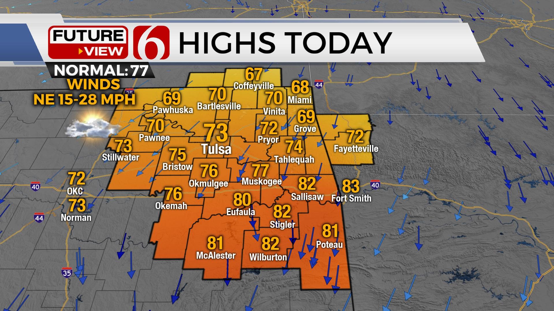
The much-advertised fall front is dropping southward on Friday morning. Gusty north to northeast winds at 15 to 25 mph will be likely for the first half of the day. Temperatures begin Friday morning in the 50s and will max out in the upper 60s and lower 70s across far northern Oklahoma, lower to mid-70s near the metro, and into the upper 70s and lower 80s across southeastern Oklahoma. A weak cut off low positioned to our west will spread some upper air energy eastward today and tomorrow resulting in a few scattered showers mostly across the western third of the state. A few showers are a possibility along the I 35 corridor region today and also for part of tomorrow. The potential for post frontal clouds across the area Saturday for most of northern Oklahoma should result in rather cool day. Regardless, temperatures are expected to start in the 40s Saturday morning across the northern third of the area and near 50 across far southeastern Oklahoma. Daytime highs tomorrow should stay in the mid to upper 60s north, and upper 60s and lower 70s south. North winds will remain at 10 to 15 mph Saturday.

The pattern will quickly modify with south winds returning Sunday and increasing speeds next week as the southwestern cut off low weakens more and ejects into the southern plains. Another strong area of low pressure aloft will move from Southern Canada into the upper Midwest early next week. The result will be a potential for a few scattered showers and storms. Any amounts are expected to be mostly light. Another strong front will approach the area Wednesday evening or early Thursday morning. Low level moisture should be in place ahead of this system, and additional shower and thunderstorm chances will return to the northern third of the state Tuesday and Wednesday. As this front moves across our area, another cool down is likely lake next week. Our pattern will remain active for the foreseeable future. This means we’ll be tracking more frontal intrusions every 4 to 5 days. Cooler weather will also be more likely in the next 2 to 3 weeks.

Friday night football games will be chilly. Game time temperatures in the 60s are likely in the Tulsa metro, with some locations in the valleys ending the games in the upper 50s. The OSU and Texas Tech game Saturday will be cool with game time temperatures mostly in the lower 60s. There will be a slight chance for showers near Stillwater Saturday. The Red River rivalry features kickoff temperatures in the lower 70s with Dallas-Fort Worth reaching the lower 80s by the end of the OU & Texas game. Tulsa travels to Annapolis Maryland playing the Naval Academy, where game time temperatures will remain in the upper 50s and lower 60s.

Thanks for reading the Friday morning weather discussion and blog.
Have a super great day!
Alan Crone
KOTV

Get The Daily Update!
Be among the first to get breaking news, weather, and general news updates from News on 6 delivered right to your inbox!
More Like This
October 7th, 2022

June 21st, 2023

June 19th, 2023

June 13th, 2023
Top Headlines

December 13th, 2024

December 13th, 2024

December 13th, 2024

December 13th, 2024