

Light Winds Before Wednesday Morning Showers
Expect another day of warm and breezy conditions before rain chances return to Green Country.Tuesday, January 17th 2023, 6:58 am
If you’re into podcasts or in a rush, check out my daily weather update. Search for NewsOn6 and ‘Weather Out The Door’ on most podcast providers, including Spotify, Stitcher and Tune-In, or Click Here to listen on Apple Podcasts.
TULSA, Okla. - Expect another day of warm and breezy conditions before rain chances return to Green Country.
Here are the details from News On 6 Meteorologist Alan Crone:

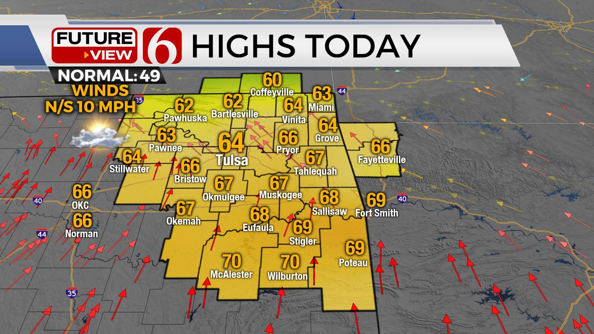
A weak boundary has moved across part of the area and will return later today or tonight as the next strong storm system nears the state. This brings a mention for scattered showers and storms beginning later Tuesday night through early Wednesday morning. Highs this afternoon should reach the lower to mid-60s near Tulsa, the lower 70s in southeastern OK and the upper 50s along the OK-KS state line region. The potential exists for a return of near normal (colder) temps for the weekend and below normal early next week.

The next upper-level system quickly nears the state this evening and exits Wednesday midday. The return of low-level moisture attempts to arrive across eastern Oklahoma as the system nears. This should result in some scattered showers and thunder before colder and drier air arrives Wednesday afternoon. The speed of the system should keep the higher threat for strong to severe storms to our southeast, but if the system slows, the threat for a few strong to severe storms could quickly sneak into far southeastern and extreme eastern sections of the state. The proximity of the cold core upper-level low may support a few low-topped strong to near severe storms across extreme northeastern OK into southeastern Kansas midday Wednesday to early afternoon. This also remains a low probability but something to monitor.

We’ll be in a holding pattern Thursday and Friday before the next system approaches the southern plains this weekend. The data remain highly inconclusive with some important features that could bring big changes to sensible weather. We’ll continue with some low-end mentions for showers by Saturday evening into early Sunday morning. There will be a potential for some wintry mix with this weekend if any precipitation lingers during the early Sunday morning period, but chances continue to remain low. Another system nears the state by the early to middle of next week with additional colder air possible. More on this tomorrow. The overall global pattern suggests the potential for a return to colder weather across the nation by the end of January and early February.

Thanks for reading the Tuesday morning weather discussion and blog.
Have a super great day!
Alan Crone
KOTV

Get The Daily Update!
Be among the first to get breaking news, weather, and general news updates from News on 6 delivered right to your inbox!
More Like This
January 17th, 2023

June 21st, 2023

June 19th, 2023

June 13th, 2023
Top Headlines

December 11th, 2024

December 11th, 2024

December 11th, 2024

December 11th, 2024