

Tracking Storm Chances This Week
Shower chances return to Green Country this week.Tuesday, May 9th 2023, 7:03 pm
If you’re into podcasts or in a rush, check out my daily weather update. Search for NewsOn6 and ‘Weather Out The Door’ on most podcast providers, including Spotify, Stitcher and Tune-In, or Click Here to listen on Apple Podcasts.
TULSA, Okla. - Shower chances return to Green Country this week.
Here are the details from News On 6 Meteorologist Alan Crone:
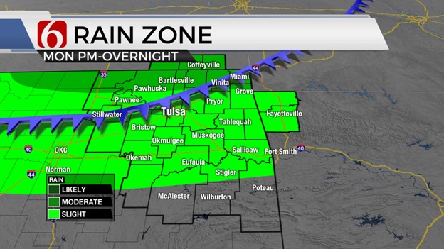
A weak boundary located across far northern Oklahoma and part of southern Kansas will be a focus for thunderstorms later this afternoon and early evening. The exact position of the boundary will hold the key to where higher storm chances occur. Regardless, thunderstorms later this afternoon into the early evening hours will be possible across the far northern third of the state. Severe weather threats will also remain possible with large hail, damaging winds, and locally heavy rainfall as the primary threat. A complex of storms will likely develop today across the central plains and dive southeast later this afternoon and evening. Some of these severe storms will attempt to enter southern Kansas and northern OK this evening. Another disturbance approaches from south and central Texas late tonight into early Wednesday providing another chance of rain and storms across the eastern half of the state by Wednesday afternoon and evening. Increasing cloud cover will limit surface instability, yet a few strong storms will remain possible. Not every location will experience showers or storms, but the additional cloud cover should keep daytime highs Wednesday into the lower 80s. This weak upper low will continue to lift east-northeast away from the area Wednesday night and early Thursday.
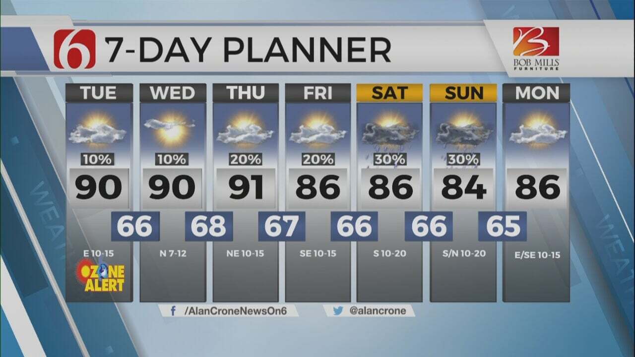
A strong western United States upper air trough will be moving across the Rockies Wednesday night into early Thursday morning providing a much stronger upper airflow across the western half of the state Thursday afternoon and early evening. The dryline is expected to be positioned across portions of extreme western OK by Thursday afternoon. While most of Oklahoma will experience a highly unstable atmosphere east of the dry line, higher chances for strong and severe storms may remain across the western half of the state into north central OK for most of Thursday afternoon before attempting to move east. A few strong and severe storms may approach our area late Thursday night into pre-dawn Friday. Friday morning, most of the stronger flow aloft will eject Northeast away from the state with a few lingering showers and storms possible. Another upper-level system will approach from the Mexican plateau Friday night into early Saturday morning bringing additional rain and storms across part of our area Saturday and early Sunday. Most data continue to support a moderately strong cold front arriving either late Saturday night or early Sunday morning with a notable decrease in temperatures for Sunday. By Sunday midday and afternoon, most showers and storms will be pushing across southern Oklahoma into North Texas giving Northern Oklahoma a respite from the summerlike weather early next week.
Thanks for reading the Tuesday morning weather discussion and blog.
As always, remain aware of your Weather surroundings.
Have a super great day!


Alan Crone
At the first hint of storms, a young Alan Crone would start watching from the big front porch of his parents' home in McAlester.

Get The Daily Update!
Be among the first to get breaking news, weather, and general news updates from News on 6 delivered right to your inbox!
More Like This
May 9th, 2023

July 3rd, 2023

June 8th, 2023
June 6th, 2023
Top Headlines


March 13th, 2025


March 13th, 2025