Another Pop-Up Storm Chance
Warm temperatures stick around on Tuesday, but parts of Green Country could see some showers.Tuesday, May 30th 2023, 5:58 am
If you’re into podcasts or in a rush, check out my daily weather update. Search for NewsOn6 and ‘Weather Out The Door’ on most podcast providers, including Spotify, Stitcher and Tune-In, or Click Here to listen on Apple Podcasts.
TULSA, Okla. - Warm temperatures stick around on Tuesday, but parts of Green Country could see some showers.
Here are the details from News On 6 Meteorologist Alan Crone:
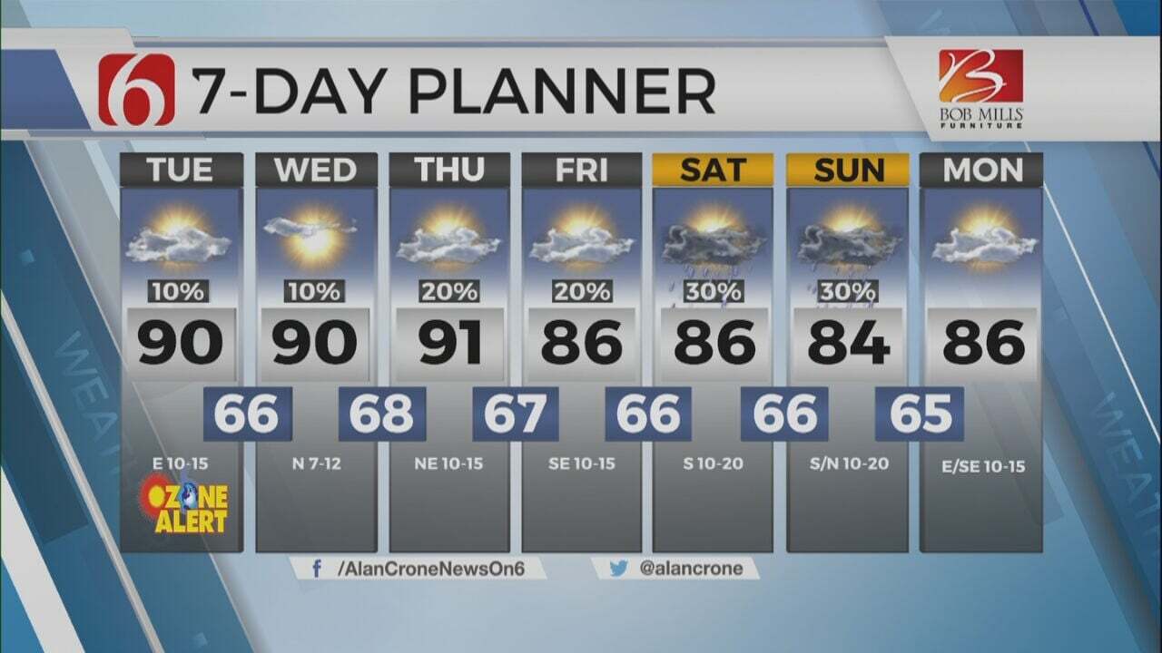
Expect another sunshine and cloud mix on Tuesday with highs in the mid 80s. A few pop-up type storms will be possible. Higher chances arrive by the end of the week and will continue through the weekend.
We’re in the type of pattern that can bring changes depending upon the exact outcome and coverage of daily thunderstorm results. In other words, what happened on Monday night can have impacts on what occurs later in the day. And what happens on Tuesday can change what happens on Wednesday. Our forecast continues with a slight chance for a pop-up thunderstorm on Tuesday, a few more Wednesday and Thursday before additional storm chances arrive into the weekend.
Later in the day, a few pop-up storms will remain possible across eastern Oklahoma into western Arkansas. Upper flow is very light and severe weather is unlikely. The few storms that do develop will produce locally heavy rainfall, cloud to ground lightning, and gusty winds. Most locations will remain dry, but a few spots will pick up storms. A few scattered storm chances will remain Wednesday morning and again through the afternoon. A complex of storms is located across the central plains this morning and will move southeast later in the day before weakening. Another round of storms will be likely across Eastern Colorado into the high plains of Texas. Some of these will take a run at northwestern OK later Tuesday night. It’s unlikely that these two systems will have any direct impact on our weather but it’s something to watch overnight into early Wednesday morning.
The upper air flow will change by the end of the week into the weekend bringing a slightly better chance of organized thunderstorms across the state. The stronger flow also supports a slightly higher mention for strong to severe storms, but the strongest flow will reside slightly south of the region this weekend with the southern stream system and another stronger well north of the state with the northern stream. Our main threat will be pockets of locally heavy rainfall along with gusty winds.
Temperatures on Tuesday and the next days will remain near and slightly above seasonal averages with morning lows in the mid to upper 60s. Afternoon highs will reach the mid to even upper 80s. A slight increase in low-level moisture brings increasing humidity values supporting slightly humid to muggy weather with dewpoints in the mid to upper 60s.
Thanks for reading the Tuesday morning weather discussion and blog.
Have a super great day!
Alan Crone
KOTV
More Like This
May 30th, 2023
July 3rd, 2023
June 8th, 2023
June 6th, 2023
Top Headlines
December 11th, 2024
December 11th, 2024
December 11th, 2024
December 11th, 2024


