Warmer Weather On The Way, Also Chances For Showers/Storms.
<p>After a cold night tonight, milder conditions will be the general rule through Christmas along with increasing chances of rain.</p>Tuesday, December 20th 2016, 8:08 pm
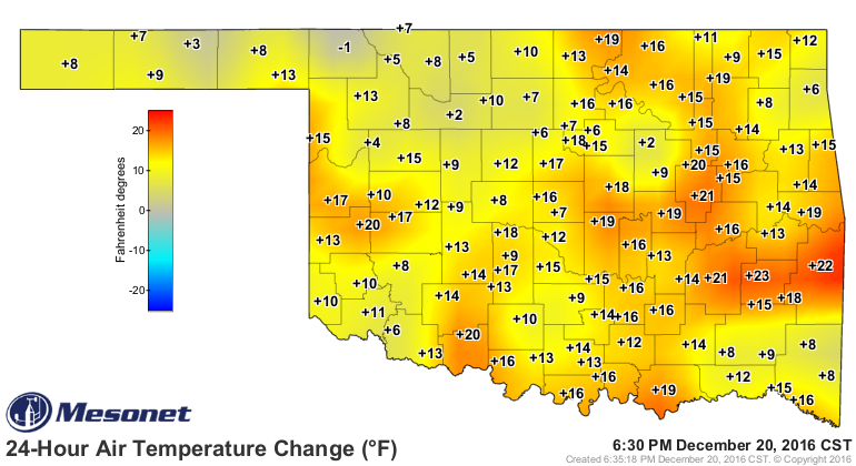
Nice warm-up today, at least compared to what we have recently experienced through the day yesterday as you can see on the 24 hour temperature change map, courtesy of the OK Mesonet. By the way, 52/20 has been the official max/min in Tulsa for today as compared to the normal values of 48/29.
[img]
This recent cold snap also produced some record low temperatures with Tulsa bottoming out at 3 Sunday morning. In addition, we had 52 consecutive hours of below freezing temperatures for Tulsa and the total number of hours of below freezing temperatures over the last week was over 100 for many locations as you can see on this map, also courtesy of the OK Mesonet.
[img]
Temperatures tonight will be cooler than normal once again with overnight lows dropping into the low-mid 20s under fair skies and despite a very light SE breeze. But, it should be moderating rather quickly on Wednesday with afternoon highs back into the lower 50s for the most part along with lots of sunshine. Our winds will be southerly at 5-10 for much of the day, shifting to the N/NW late as another cool front moves across the state. This will be a dry system as it has no moisture to work with and will be followed by somewhat cooler conditions on Thursday as you can see on our forecast page.
A return to southerly winds on Friday will start another warming trend and a storm system now located in the Pacific will be making a run at us bringing mostly cloudy skies and chances of rain for Friday. Saturday will also see mostly cloudy skies and chances of showers along with gusty southerly winds. Those winds will result in much milder than normal conditions for Christmas Eve with temperatures into the 50s that afternoon and not cooling much that night.
In fact, Christmas Day will likely start off with cloudy skies, gusty southerly winds, temperatures still in the 50s, and chances of showers. There are still some timing differences from the longer range guidance going through Christmas Day and into the day Monday. But, the bottom line is that the guidance is consistent in keeping us in the warm sector all day before another cold front arrives either that evening or Monday morning. That means temperatures should be in the 60s which means it will be warm enough and unstable enough for storms to be a possibility for the afternoon into the night time hours. Some of those could be severe although it is far too early to be any more specific than that. At any rate, notice the 7 day QPF does have the eastern half of the state with the potential for some decent moisture for the first time in a long while.
[img]
That will be followed by a cool-down for early next week but not to the extremes we just experienced. These next several cool fronts that will be passing through the state are primarily of Pacific origin so we do not see a return of arctic air anytime soon. In fact, the 8-14 day outlook suggests temperatures, on average, should be running above normal for that time period. That time period should also be more active with respect to at least some additional chances for precipitation.
[img]
[img]
In the meantime, stay tuned and check back for updates.
Dick Faurot
More Like This
December 20th, 2016
September 29th, 2024
September 17th, 2024
Top Headlines
December 11th, 2024
December 11th, 2024
December 11th, 2024
December 11th, 2024


