News
News Home
Tulsa Race Massacre
Remembering Toby Keith
Something Good
Coca-Cola Porch
Oklahoma's Own In Focus
Oklahoma Media Center
Alex Cameron
Crime
Lori's Safety Tips
Gathering Place
Educate Oklahoma
[Unfiltered]
Coronavirus
Politics
Covering the Capitol
Special Coverage
Oklahoma Earthquakes
Events
Weather
Weather Home
Bob Mills Weather Center
WARN Radar
National Radar
Watches & Warnings
Osage SKYCAMS
SkyNews 6 HD
Trav's Wild Weather Camp
Alan's Bus Stop Forecast
Weather App
Ahead of The Storm
Weather 101
Trav's Storm Map
Live Bald Eagle Cam
Weather Teller
Lake Levels
Traffic
Sports
Sports Home
WCWS
FC Tulsa
OU
OSU
TU
ORU
Thunder
Ford Sports Blitz
Our State, Our Heisman
High School Football
Scores & Schedules
Athlete of the Week
Play of the Week
Spirit Stick
PGA 2022
Oklahoma's Own Originals
Home
Remembering Toby Keith
Weather Vault
Tulsa Race Massacre: 100 Years Later
Oklahoma Together
Something Good
Reign of Terror
Trips On A Tankful
Ahead of the Storm
Missing Not Forgotten
We Remember: 25 Years Later
Holiday Adventures Week: 2020
State Fair Stories
Tulsa Race Massacre: 2021 Coverage
First and Football
Summer Staycations
Tulsa Special Reports
Crime Stories with Lori Fullbright
The Gathering Place
Craig Day Stories
Top Ten Car Chases
Fall Getaways
Remembering Toby Keith
Video
Video Home
Video Sales
Contests
Contests Home
Text & Win
Recipes
Recipes Home
About Us
About Us Home
Meet the News Team
Products
Advertise with Us
Food for Kids
Osage SkyNews 6 HD
News On 6 Requests
TV Schedule
NOW Cable Listings
Tulsa's CW
Seen On
Seen On
Everyday Heroes
Links Mentioned
Women's History Month
Missing Not Forgotten
Daily Pledge
Oklahoma Together
Careers
Job Listings
Brand Focus
Brand Focus
Account
Sign Up
Log In
News
Weather
Videos
Sports
|
Trending:
Kosovo Stories
We Remember
LIVE
°
0
Trending:
Kosovo Stories
We Remember
Watch Live by A-Best Roofing
: News On 6 In The Morning
Alan Crone
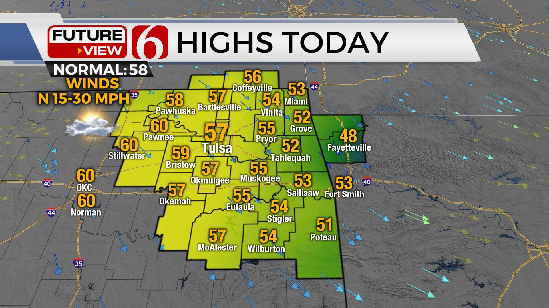
Another Pleasant Day With Cooler Temps; Warm Up Returns By Weekend
Alan Crone
The cooler weather Tuesday morning is expected to stick around through Wednesday, before high heat returns later this week.
A Pleasant Break From The Heat Early This Week
Alan Crone
After a weekend full of storms, the early part of this week features cooler weather.
Hot And Humid Before A Sunday Cold Front
Alan Crone
More heat warnings remain Friday and Saturday before some changes occur as storm chances bring some relief from the heat. Afternoon highs in the 100 to 104 range are likely.
Weekend Storm Chances Bring Cooler Weather Next Week
Alan Crone
The mid-level ridge is starting to change shape this morning, and will slowly migrate away from the area later soon. Expect hot weather to continue into your Thursday.
Triple-Digit Temps, High Heat Index Values On Wednesday
Alan Crone
Triple digit high temperatures combined with abundant low-level moisture will yield heat index values from 110 to 116 Wednesday afternoon.
A Pattern Change Arriving This Weekend
Alan Crone
Excessive heat and humidity will continue across Northeastern Oklahoma for the remainder of the week, but some changes should arrive this weekend.
View More Stories
Triple-Digit Highs, Heat Advisories To Last All Week In Oklahoma
Alan Crone
The hottest stretch of the summer season to date will be arriving over the next several days.
Triple-Digit Highs, Heat Advisories To Last All Week In Oklahoma
Alan Crone
The hottest stretch of the summer season to date will be arriving over the next several days.
A Hot Weekend Coming Up
Alan Crone
A weak mid-level convergence zone across eastern Oklahoma could result in a few high based showers or even a rumble of thunder Friday morning.
A Hot Weekend Coming Up
Alan Crone
A weak mid-level convergence zone across eastern Oklahoma could result in a few high based showers or even a rumble of thunder Friday morning.
Heat And Humidity Continue Amid High Temps
Alan Crone
The heat dome will remain the dominate weather feature across the state for the next several days as it continues to expand eastward, eventually centering across the state Sunday into early next week.
Heat And Humidity Continue Amid High Temps
Alan Crone
The heat dome will remain the dominate weather feature across the state for the next several days as it continues to expand eastward, eventually centering across the state Sunday into early next week.
More Heat And Humidity As Temps Rise
News On 6
Gusty southwest winds from 20 to near 30 mph will be likely through the afternoon, with daytime highs reaching the upper 90s and a few triple digits.
More Heat And Humidity As Temps Rise
News On 6
Gusty southwest winds from 20 to near 30 mph will be likely through the afternoon, with daytime highs reaching the upper 90s and a few triple digits.
Oklahoma Heat Advisory In Affect As Temperatures Climb Toward Triple-Digits
Alan Crone
Heat and humidity will be the dominant feature across most of the state for the rest of the week and into the weekend as a mid-level ridge of high pressure expands across the area.
Oklahoma Heat Advisory In Affect As Temperatures Climb Toward Triple-Digits
Alan Crone
Heat and humidity will be the dominant feature across most of the state for the rest of the week and into the weekend as a mid-level ridge of high pressure expands across the area.
Summer Pattern Underway, Low Storm Chances Later This Week
Alan Crone
The mid-level ridge of high-pressure will remain centered west of the state today but the expanding periphery of the ridge will bring seasonably hot conditions to Oklahoma for most of the week.
Summer Pattern Underway, Low Storm Chances Later This Week
Alan Crone
The mid-level ridge of high-pressure will remain centered west of the state today but the expanding periphery of the ridge will bring seasonably hot conditions to Oklahoma for most of the week.
View More Stories
Severe Storms Move Into Green Country
Alan Crone
Watches and Advisories are in effect on Friday morning as a round of storms sweeps across Green Country.
Severe Storms Move Into Green Country
Alan Crone
Watches and Advisories are in effect on Friday morning as a round of storms sweeps across Green Country.
More Rainfall Expected Around Green Country This Weekend
Alan Crone
The upper air pattern remains from the Northwest and will bring several storm systems into the area for the next few days.
More Rainfall Expected Around Green Country This Weekend
Alan Crone
The upper air pattern remains from the Northwest and will bring several storm systems into the area for the next few days.
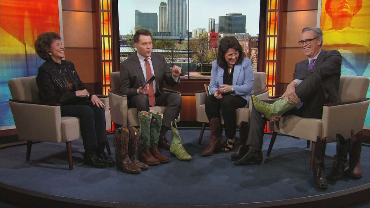
Oh Kaye! Those Cowboy Boots Are For Alan Crone
News On 6
Back in February, LeAnne's mom came on the show and noticed Alan Crone not wearing his cowboy boots! So she made it her mission to get him some new boots and now it's time to see if the boot fits.
Oh Kaye! Those Cowboy Boots Are For Alan Crone
News On 6
Back in February, LeAnne's mom came on the show and noticed Alan Crone not wearing his cowboy boots! So she made it her mission to get him some new boots and now it's time to see if the boot fits.
Chilly Weather Returns To Northern Oklahoma
Alan Crone
The cold front has cleared most of the region but remains across far southeastern Oklahoma this morning where warmer weather remains for the next few hours.
Chilly Weather Returns To Northern Oklahoma
Alan Crone
The cold front has cleared most of the region but remains across far southeastern Oklahoma this morning where warmer weather remains for the next few hours.
Improving Weather This Weekend
Alan Crone
The powerful upper-level system is moving across Eastern Oklahoma this morning along with a stout surface low pressure area along the Red River.
Improving Weather This Weekend
Alan Crone
The powerful upper-level system is moving across Eastern Oklahoma this morning along with a stout surface low pressure area along the Red River.
View More Stories
Most Popular
Cursive Handwriting Bill Signed Into Law By Gov. Kevin Stitt
News On 6
A bill that requires all Oklahoma public and charter schools to teach cursive writing to students in third through fifth grades has been signed into law.
Cursive Handwriting Bill Signed Into Law By Gov. Kevin Stitt
News On 6
A bill that requires all Oklahoma public and charter schools to teach cursive writing to students in third through fifth grades has been signed into law.
GolfSuites Employees Speak Out Following Abrupt Closure
Kaitlyn Deggs
The employees say it’s scary to go from having a job one day to not having one the next and now they’re scrambling to find new jobs.
GolfSuites Employees Speak Out Following Abrupt Closure
Kaitlyn Deggs
The employees say it’s scary to go from having a job one day to not having one the next and now they’re scrambling to find new jobs.
New Apartments Along Route 66 In Tulsa Market District Now Open
MaKayla Glenn
NOMA or "North of Market Area" is a mixed-use development on the northwest corner of 11th and Lewis Ave. The 450,000 square foot development has made steady progress since its launch in 2021.
New Apartments Along Route 66 In Tulsa Market District Now Open
MaKayla Glenn
NOMA or "North of Market Area" is a mixed-use development on the northwest corner of 11th and Lewis Ave. The 450,000 square foot development has made steady progress since its launch in 2021.
View More Stories
Most Popular
Cursive Handwriting Bill Signed Into Law By Gov. Kevin Stitt
News On 6
A bill that requires all Oklahoma public and charter schools to teach cursive writing to students in third through fifth grades has been signed into law.
GolfSuites Employees Speak Out Following Abrupt Closure
Kaitlyn Deggs
The employees say it’s scary to go from having a job one day to not having one the next and now they’re scrambling to find new jobs.
New Apartments Along Route 66 In Tulsa Market District Now Open
MaKayla Glenn
NOMA or "North of Market Area" is a mixed-use development on the northwest corner of 11th and Lewis Ave. The 450,000 square foot development has made steady progress since its launch in 2021.
Federal Trade Commission Releases New Rule Which Could Lead To Salary Increases Across The Country
Jayden Brannon
The Federal Trade Commission issued new rules that will affect many workers in Oklahoma. One of the rules has to do with salaried employees who work overtime.
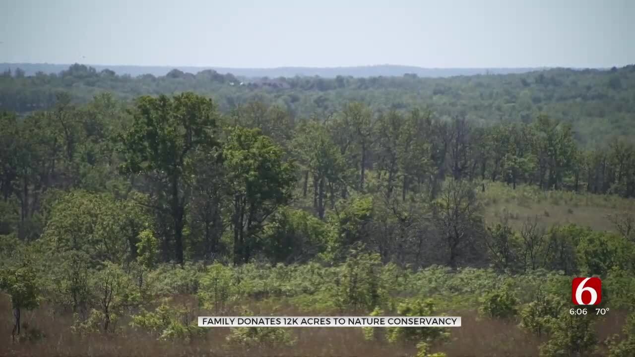
Creek County Family Donates 12,000 Acres To The Nature Conservancy
Amy Slanchik
The Nature Conservancy said the 12,000-acre ranch is in "outstanding" condition, supporting plants and animals. The previous owners wanted the public to enjoy the space.
'We Failed In This Situation': Bartlesville Police Chief Comments On Footage Of Officer Arresting Woman
Cal Day
Body camera video shows a Bartlesville police officer putting his hands in a woman’s face and yelling at her after putting her under arrest. The woman says she was taking her granddaughter to the hospital when she got stopped.
View More Stories
View More Stories